Ministry of Mines » Ontario Geological Survey » Publications Release Notices
Ministry of Mines » OGS » PUB Release notices
Ontario Geological Survey Publications Release Notices
The following publications are available now for free download from GeologyOntario, or by following the links provided in this release notice.
Maps and reports in hard-copy (paper) format and digital data sets available on physical media (CD or DVD) can be purchased from the Publication Sales office.
In cases where the file size is prohibitive for downloading, please contact the Publication Sales office to obtain the data on physical media (CD for $20.00; DVD for $25.00).
The digital data provided with maps as downloadable zip files from GeologyOntario contain additional information that supplements the cartographic information, and is provided at the discretion of the author(s).
Prices listed in this Release Notice apply to hard-copy versions only and are subject to change without notice. The prices given in a particular release notice are guaranteed only for a period of 1 month following the date of the release.
To automatically receive the Publications Release Notice by email, subscribe to the distribution list by emailing Publication Sales.
Errors may occur in some publications. A list of publications containing errors can be viewed on the Errata Web page.
We are committed to providing accessible customer service. If you need accessible formats or communications supports, please contact us.
Publications Release Notice — April 24, 2024
Earth Resources and Geoscience Mapping Section
Surficial Mapping and Sampling
Preliminary Map P.3676
Surficial Geology of the Island Lake Area Southeast, Northern Ontario; by C. Gao and K.H. Yeung, scale 1:100 000, colour. $11.60
Preliminary Map P.3677
Surficial Geology of the Opasquia Lake Area Southwest, Northern Ontario; by C. Gao and K.H. Yeung, scale 1:100 000, colour. $11.60
Preliminary Map P.3678
Surficial Geology of the Opasquia Lake Area Southeast, Northern Ontario; by C. Gao and K.H. Yeung, scale 1:100 000, colour. $11.60
Preliminary Map P.3689
Surficial Geology of the Deer Lake Area North, Northern Ontario; by C. Gao and K.H. Yeung, scale 1:100 000, colour. $12.85
Preliminary Map P.3690
Surficial Geology of the North Spirit Lake Area Northwest, Northern Ontario; by C. Gao and K.H. Yeung, scale 1:100 000, colour. $11.60
Preliminary Map P.3691
Surficial Geology of the North Spirit Lake Area Northeast, Northern Ontario; by C. Gao and K.H. Yeung, scale 1:100 000, colour. $11.60
Preliminary Map P.3702
Surficial Geology of the Deer Lake Area South, Northern Ontario; by C. Gao and K.H. Yeung, scale 1:100 000, colour. $12.85
Preliminary Map P.3703
Surficial Geology of the North Spirit Lake Area Southwest, Northern Ontario; by C. Gao and K.H. Yeung, scale 1:100 000, colour. $11.60
Location Map (PDF)
2024 Publications
Earth Resources and Geoscience Mapping Section
Geophysics
Airborne Geophysical Survey
Winisk River Area
1:50 000 Scale Map Sheets
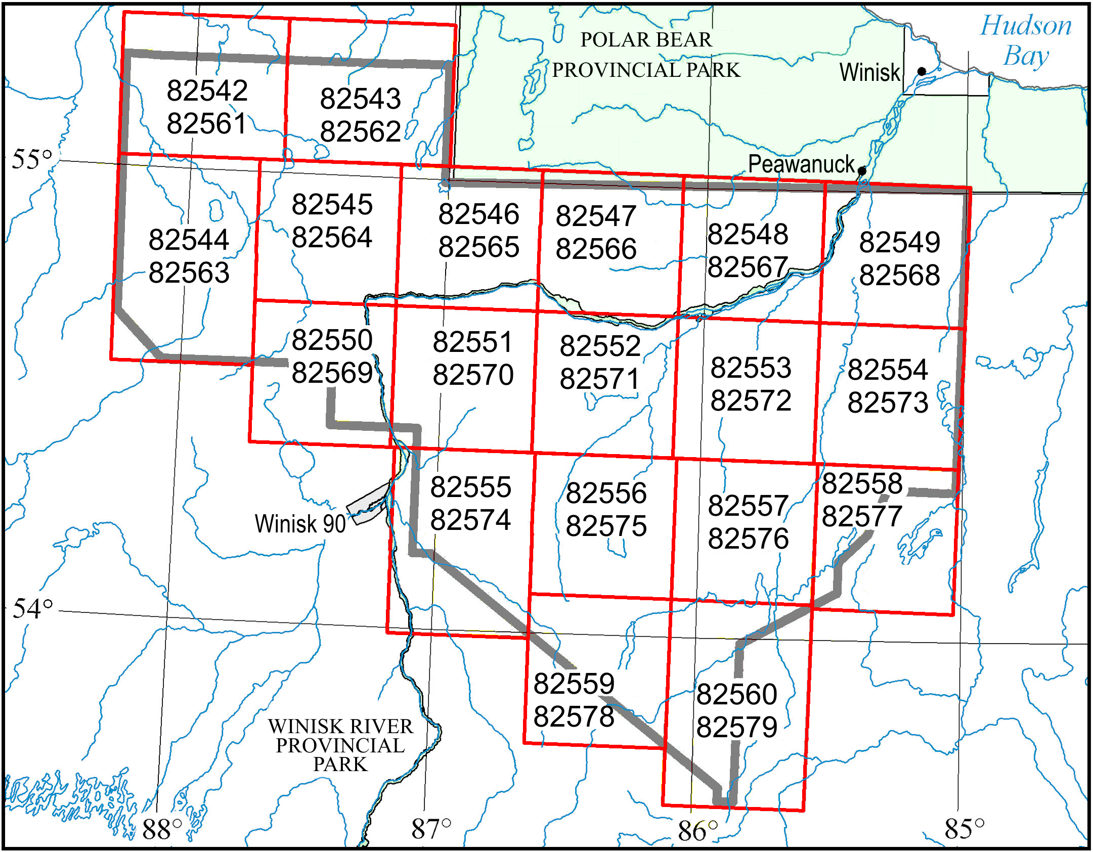
Map 82 542, Map 82 543, Map 82 544, Map 82 545
Map 82 546, Map 82 547, Map 82 548, Map 82 549
Map 82 550, Map 82 551, Map 82 552, Map 82 553
Map 82 554, Map 82 555, Map 82 556, Map 82 557
Map 82 558, Map 82 559, Map 82 560
Airborne Magnetic Gradiometer Survey, Colour-filled Contours of the Residual Magnetic Field, Winisk River Area; by Ontario Geological Survey, scale 1:50 000, colour. Map prices range from $12.10 to $13.25.
Map 82 561, Map 82 562, Map 82 563, Map 82 564
Map 82 565, Map 82 566, Map 82 567, Map 82 568
Map 82 569, Map 82 570, Map 82 571, Map 82 572
Map 82 573, Map 82 574, Map 82 575, Map 82 576
Map 82 577, Map 82 578, Map 82 579
Airborne Magnetic Gradiometer Survey, Shaded Colour Image of the First Vertical Derivative of the Residual Magnetic Field and Keating Correlation Coefficients, Winisk River Area; by Ontario Geological Survey, scale 1:50 000, colour. Map prices range from $12.00 to $13.80.
Geophysical Data Set
Geophysical Data Set 1069
Ontario Airborne Geophysical Surveys, Magnetic Gradiometer Data, Grid and Profile Data (ASCII and Geosoft® Formats) and Vector Data, Winisk River Area; by Ontario Geological Survey. The data are available on 1 DVD. $25.00
Miscellaneous
2021–2023 Indexes to Publications
The Ministry of Mines has prepared interim supplements to Miscellaneous Papers (MP) 177 and 178 for publications released in 2021, 2022 and 2023. Miscellaneous Paper 177 (Interim Supplement 2021–2023) and MP 178 (Interim Supplement 2021–2023) are available as free downloads or can be purchased in hard-copy format from Publication Sales.
Miscellaneous Paper (MP) 177 (Interim Supplement 2021–2023)
Index to Published Reports, Maps and Digital Data, 2021–2023
This index provides a listing of all publications released since the publication of MP 177 (Supplement 2016–2020), Index to Published Reports, Maps and Digital Data, 2016 to 2020, to the end of 2023. Publications are listed by series only. 35p. $8.40
Miscellaneous Paper (MP) 178 (Interim Supplement 2021–2023)
Geographic Index to Published Reports, Maps and Digital Data, 2021–2023
This index provides a listing of all publications released since the publication of MP 178 (Supplement 2016–2020), Geographic Index to Published Reports, Maps and Digital Data, 2016 to 2020, to the end of 2023. Publications are indexed by geographic areas, which include National Topographic System (NTS) areas, geographic townships and Ministry of Natural Resources (MNR) “areas”. Publications are listed under the main geographic areas where they are located. 37p. $8.45
Erratum
Preliminary Map P.3829, Precambrian Geology of the Wabassi River Area, Fort Hope–Miminiska Greenstone Belt, Northwestern Ontario (released June 30, 2021), was published with an error in the marginal notes. In the first paragraph under “Mineral Potential”, a value of 29.8 g/t was stated for Au, where it should have been for Ag. The text should say: “The National Instrument 43-101–compliant Inferred Resources for the deposit are 1.04 million tonnes grading 1.10% Cu, 4.21% Zn, 29.8 g/t Ag…..” (not 29.8 g/t Au).
This error has been corrected and a replacement map is available. If you purchased a copy of this map, please contact Publication Sales and a replacement map will be sent to you free of charge. Alternatively, and for clients who downloaded the map from GeologyOntario, the corrected version of Preliminary Map P.3829 is available to download.
We regret any inconvenience this error may have caused.
Location Map (PDF)
Earth Resources and Geoscience Mapping Section
Groundwater Studies
Open File Report 6406
Ontario Groundwater Geoscience 2024 Open House; compiled by A.K. Burt, L.M. Colgrove, K.J.J. Kalmo, D. Ford, S. Holysh and H.A.J. Russell, 47p. $9.00
Location Map (PDF)
Resident Geologist Program
Recommendations for Exploration 2023–2024 (PDF)
The Ontario Geological Survey (OGS) is pleased to issue its Recommendations for Exploration 2023–2024. These recommendations are the product of the dedicated and knowledgeable staff located in the 8 Resident Geologist Program (RGP) offices across the province. The recommendations have been developed using existing OGS geological and exploration data, along with new information derived from the current year’s activities. 74p. Available online only.
Announcement
Ontario Groundwater Geoscience Open House
February 27, 2024
From 9:00 a.m. to 5:00 p.m. EST
In-person event
Federation Hall, University of Waterloo,
200 University Avenue West, Waterloo, Ontario
Also available as virtual event hosted via Microsoft® Teams® live platform
and
February 29, 2024
From 12:30 p.m. to 5:00 p.m. EST
Virtual event hosted via Microsoft® Teams® live platform
The 2024 open house for the Ontario Groundwater Community will consist of 2 days of presentations hosted collaboratively by the Ontario Geological Survey, the Geological Survey of Canada, and Conservation Authorities of Ontario. Both days will include presentations by federal government, provincial government, Conservation Authority, academic and private sector collaborators involved in groundwater studies in Ontario. The objective of the open house is to update groundwater practitioners and water managers on the activities of the respective agencies and collaborators. Register through Eventbrite.
Erratum
In Open File Report 6403, Report of Activities 2022, Resident Geologist Program, Kirkland Lake Regional Resident Geologist Report: Kirkland Lake and Sudbury Districts (released July 18, 2023), the authorship on the title page was incorrectly stated. The “by” line should read: “P.J. Chadwick, A.S. Péloquin, J. Suma-Momoh, R.M. Easton, P. Bousquet, P.S. LeBaron, C.M. Daniels, S.L.K. Hinz, R.M. Todd, B.B. McKinnon, G. Dorland and N. Sabiri”. The authorship in the example references on the title page and on page iii were similarly incorrect.
These errors have been corrected (as of December 18, 2023). You may download the corrected version of Open File Report 6403 from our GeologyOntario Web site.
We regret any inconvenience these errors may have caused.
Location Map (PDF)
2023 Publications
Miscellaneous
Open File Report 6405Summary of Field Work and Other Activities, 2023; by Ontario Geological Survey, 390p. The Contents may be viewed on the Summary of Field Work and Other Activities Web page. $14.90
Location Map (PDF)
Announcement
Ontario Geological Survey Virtual Showcase 2023
November 28–30, 2023
Free Virtual Event (3 half-days)
Join the Ministry of Mines for a three-day virtual event showcasing Ontario Geological Survey (OGS) projects, geoscience activities, products and services. Program highlights include
- updates on current OGS projects
- OGS activities supporting critical minerals exploration
- geological updates and insights from our Resident Geologist Program offices across Ontario
- demonstrations of the new search tools and functions on GeologyOntario, the OGS Web site for online distribution of maps, reports and digital data sets
- experiencing the new OGS Virtual Field Trip: Highlights of the Proterozoic Geology in the Thunder Bay Area
- a student information session with OGS geoscientists that includes a presentation followed by questions and answers (Q&A)
Visit the event page to register or to see the full program. This event will be presented in English only.
Download the full program.
For more information, contact us at ogs@ontario.ca.
Earth Resources and Geoscience Mapping Section
Surficial Mapping and Sampling
Miscellaneous Release—Data 388
Indicator Mineral and Bulk Geochemistry Data of the Till and Other Surficial Samples Collected in the Pickle Lake–Cat Lake Area, Northern Ontario; by C. Gao, D.C. Crabtree, S.A. Clarke and K.H. Yeung. The digital data present the results on heavy mineral grain counts and bulk geochemistry of till and other glacial sediments, e.g., glaciofluvial and glaciolacustrine, as well as the postglacial peat collected during the summer field season of 2019 in the Pickle Lake–Cat Lake area of northern Ontario. The files contain specific information on sample site locations, sample processing data, gold, base metal and precious metal grain data of the till samples, and bulk geochemical inductively coupled plasma mass spectrometry (ICP–MS) and, in part, instrumental neutron activation analysis (INAA) data from the less than 0.063 mm fraction of the till, glaciofluvial and glaciolacustrine deposits and postglacial peat samples. The glaciolacustrine silt and clay and postglacial peat samples were obtained primarily using a hand–held Dutch soil auger with extension rods; the ICP–MS data from these samples provide, together with the till samples, the baseline surficial geochemical information for this region. Data are available as 21 Microsoft® Excel® for Office 365 (.xlsx) files and are accompanied by supporting documentation in portable document format (.pdf). The data are available on 1 CD. $20.00
Miscellaneous Release—Data 400
Indicator Mineral and Geochemistry Data of Till and Other Surficial Samples in the Sandy Lake Area, Northwestern Ontario; by C. Gao and K.H. Yeung. The digital data present the results on heavy mineral grain counts and bulk geochemistry of glacial sediments (till mostly) and postglacial lacustrine silt and clay and surface peat collected in 2017 and 2018 in the Sandy Lake area, northwestern Ontario. The files contained specific information on sample site locations, sample processing data, gold, base metal, and precious metal grain data of the till samples, and bulk geochemical data from the less than 0.063 mm fraction of the till, lacustrine silt and clay and surface peat samples. The glaciolacustrine silt and clay and postglacial peat samples were obtained mainly using a hand-held Dutch soil auger with extension rods; the inductively coupled plasma mass spectrometry (ICP—MS) and inductively coupled plasma atomic emission spectrometry (ICP—AES) data from these samples provide, together with the till samples, the baseline surficial geochemical information for this region. Data are available as 16 Microsoft® Excel® for Office 365 (.xlsx) files. The data are available on 1 CD. $20.00
Groundwater Studies
Groundwater Resources Study 21
Ambient Groundwater Geochemistry Project Field Methods and Procedures; by C.N. Bocking, S.M. Hamilton and K.M. Dell. This Groundwater Resources Study (GRS) presents the standard field work methods and procedures used in the Ambient Groundwater Geochemistry Project (AGGP). The AGGP collects groundwater samples from domestic, farm and monitoring wells at a high regional sample density of 2 samples per 10 by 10 km grid cell across southern and parts of northern Ontario. The samples were characterized to a high degree of analytical completeness and published in Miscellaneous Release—Data 283 – Revision 2; a corresponding database for northeastern Ontario is pending. Data currently in the database were collected between 2007 and 2019 using a consistent sampling methodology for the more than 4000 samples collected so far. The purpose of this publication is to describe those field protocols, which have also been used in a variety of add-on and third-party studies to date. Defensible and consistent sample collection protocols are of the first importance in the scientific characterization of groundwater chemistry. This release comprises 1 document in portable document format (.pdf) and is available on 1 CD. $20.00
Miscellaneous
The Ontario Geological Survey is pleased to announce the release of 10 geological guidebooks originally prepared for field trips held in conjunction with the joint annual meeting of the Geological Association of Canada, the Mineralogical Association of Canada and the Society for Geology Applied to Mineral Deposits (GAC–MAC–SGA), in Sudbury, Ontario, May 25–27, 2023. All the guidebooks, including those of cancelled field trips, have been edited and formatted for release as Open File Reports.
Open File Report 6388
Paleozoic Geology of Manitoulin Island and Adjacent North Channel Islands, Northeastern Ontario: A Geological Guidebook; by F.R. Brunton, K.E. Hahn, C. Béland Otis and P.J. Julig, 62p. $9.55
Open File Report 6389
Ice on the Rocks: The Quaternary Geology of Sudbury and Surrounding Region: A Geological Guidebook; by R.P.M. Mulligan, A.K. Burt, G.W. Hagedorn and A.S. Marich, 49p. $9.80
Open File Report 6391
Base, Critical, and Precious Metals Mineralization in the Metasomatic Iron and Alkali-Calcic Systems of the Southern Province in the Sudbury Area: A Geological Guidebook; by M. Hamilton, J.-F. Montreuil, E. Adlakha, L. Corriveau and W. Bain, 66p. $10.60
Open File Report 6392
Discovering the Abitibi Gold Belt: A Geological Guidebook; by S. Perrouty, R.L. Sherlock and J.M. Simmons, 42p. $10.15
Open File Report 6393
Geological Traverse of the Sudbury Impact Structure and Evolution of the Impact Melt: A Geological Guidebook; by D. Peters, S. Baurier Aymat, A.S. Péloquin, C.A. Gordon and C.M. Lesher, 67p. $10.45
Open File Report 6394
Multiscale and Polyphase Deformation Structures in the Grenville Front Tectonic Zone near Sudbury: A Geological Guidebook; by D. Jiang and C. Li, 27p. $9.35
Open File Report 6395
Exploring Differential Metal Endowment: A Comparison of the Western (Swayze) and Eastern (Rouyn-Noranda) Abitibi Greenstone Belt: A Geological Guidebook; by H.L. Gibson, T.P. Gemmell, T.R.C. Jørgensen, E.C.G. Hastie, M.D. Schofield, R. Haugaard, A.R. Smith, B. McKinley, M.I. Rees, B. Lafrance, R.L. Sherlock and B. Chapon, 100p. $11.50
Open File Report 6396
Paleoproterozoic Glacial, Microbially Induced, and Tidal Deposits of the Huronian Supergroup, Elliot Lake Region, Northeastern Ontario: A Geological Guidebook; by P.L. Corcoran and C.M. Hill-Svehla, 21p. $9.10
Open File Report 6397
Sudbury Offset Dikes and Associated Nickel-Copper-Platinum Group Element Mineralization: A Geological Guidebook; by H.V.L. Seibel and C.M. Lesher, 80p. $10.95
Open File Report 6398
Orogenic and Intrusion-Related Gold Deposits of the Michipicoten and Mishibishu Greenstone Belts in the Wawa Region, with an Emphasis on their Structural Timing and Setting: A Geological Guidebook; by C. Ma, L.E.D. Vice, C.J.R. Nagy, Z.V. Adam, D. Shirriff, B. Lafrance and L. Robichaud, 57p. $10.30
Announcement
GeologyOntario
Following the launch of the new online GeologyOntario portal at the Prospectors and Developers Association of Canada (PDAC) convention in March 2023, the Ministry of Mines has continued to maintain and update the old version of GeologyOntario to allow a transition period for users.
On December 1, 2023, the search engine of the old GeologyOntario will be turned off and all files from the old version will be removed. Please be sure to update Web browser bookmarks and to become familiar with the new portal before that date.
Errata
In Miscellaneous Release—Data 283 – Revision 2, Ambient Groundwater and Isotopic Data for Southern Ontario, 2007–2019 (released December 17, 2021), a few errors were noted in the reporting of units and data. The Microsoft® Excel® data file (MRD283-REV2_data.xlsx) and Support Document (MRD283-REV2_support_document.pdf) were affected as follows:
MRD283-REV2_data.xlsx:
- The units for boron (B), iron (
Fe ), strontium (Sr) and silicon (Si), reported in row 2, should be µg/L, not mg/L. - Data reported under “Eh(modelled)” should be multiplied by 1000 to represent values in mV.
MRD283-REV2_support_document.pdf:
- The units for boron (B), iron (Fe), strontium (Sr) and silicon (Si) are incorrect in the “Major Parameters and Trace Anions” section of Table 1 (p.6 and 7). They should be µg/L, not mg/L.
These errors have now been corrected (as of October 31, 2023). You may download the corrected version of MRD 283—Revision 2 from our GeologyOntario Web site. If you purchased physical media (DVD) of this release, please contact the Publication Sales office and a replacement copy will be sent to you free of charge.
We regret any inconvenience these errors may have caused.
Location Map (PDF)
Resident Geologist Program
Open File Report 6399
Report of Activities 2022, Resident Geologist Program, Red Lake Regional Resident Geologist Report: Red Lake and Kenora Districts; by P.M. Malegus, C.E. Kurcinka, E.G. Amyotte, K.E. Wiebe, S.A. Ferguson, T.K. Pettigrew and G. Dorland, 130p. $11.80
Open File Report 6400
Report of Activities 2022, Resident Geologist Program, Thunder Bay North Regional Resident Geologist Report: Thunder Bay North District; by S.V. Churchley, G.F. Paju, C.E. Kurcinka, T.K. Pettigrew, G. Dorland and S.A. Ferguson, 99p. $10.50
Open File Report 6401
Report of Activities 2022, Resident Geologist Program, Thunder Bay South Regional Resident Geologist Report: Thunder Bay South District; by D.A. Campbell, J.R.B. Jonsson, S.Y. Bautista, G. Dorland, T.K. Pettigrew and S.A. Ferguson, 112p. $11.35
Open File Report 6402
Report of Activities 2022, Resident Geologist Program, Timmins Regional Resident Geologist Report: Timmins and Sault Ste. Marie Districts; by Z. Azadbakht, M. Krukowski, B.K. Maity, P. Bousquet, C.M. Daniels, S.L.K. Hinz, C.J. Adrianwalla, G. Dorland, N. Sabiri and C. Patterson, 157p. $11.80
Open File Report 6403
Report of Activities 2022, Resident Geologist Program, Kirkland Lake Regional Resident Geologist Report: Kirkland Lake and Sudbury Districts; by P.J. Chadwick, A.S. Péloquin, J. Suma-Momoh, R.M. Easton, P. Bousquet, P.S. LeBaron, C.M. Daniels, S.L.K. Hinz, R.M. Todd, B.B. McKinnon, G. Dorland and N. Sabiri, 226p. $13.95
Open File Report 6404
Report of Activities 2022, Resident Geologist Program, Southern Ontario Regional Resident Geologist Report: Southeastern Ontario and Southwestern Ontario Districts and Petroleum Operations; by L.A. Mancini, M. Dorado-Troughton, J. Swiercz, P.S. LeBaron, S.L.K. Hinz, N. Sabiri, G. Dorland and L. Fortner, 78p. $9.65
Location Map (PDF)
Earth Resources and Geoscience Mapping Section
Precambrian Geology – Proterozoic and Grenville Province
Preliminary Map P.3850 Precambrian Geology of the Renfrew Area, Grenville Province, Southern Ontario; by M. Duguet, scale 1:50 000, colour. Geological, geochemical and geophysical data available as Miscellaneous Release—Data 398 (see below). $16.25
Miscellaneous Release—Data 398
Geological, Geochemical and Geophysical Data Related to the Renfrew Area, Grenville Province, Southern Ontario; by M. Duguet. This release contains field photographs, whole-rock geochemical data and magnetic susceptibility data collected during reconnaissance mapping in the summer of 2018 as part of the Renfrew 1:50 000 scale compilation mapping project. These data supplement work previously performed by the Ontario Geological Survey, which was used for the 1:50 000 scale compilation map of the Renfrew area. This release comprises 28 images (as .jpg files), 2 Microsoft® Excel® for Office 365 (.xlsx) workbook files and 4 documents in portable document format (.pdf), including a previously published Summary of Field Work and Other Activities article related to the project. These data augment Preliminary Map P.3850, Precambrian Geology of the Renfrew Area, Grenville Province, Southern Ontario; the geological legend for the map is also provided. The data are available on 1 CD. $20.00
Announcements
Ontario Geological Survey Virtual Showcase 2022 (Excerpts) Update
Additional selected presentations from the Ontario Geological Survey Virtual Showcase 2022 are available to download until October 31, 2023. The presentations are provided in video (.mp4) format and are accompanied by the OGS Virtual Showcase 2022 Technical Program and other documentation in portable document format (.pdf).
The New GeologyOntario
The Ministry of Mines launched a new online GeologyOntario portal at the 2023 Prospectors and Developers Association of Canada (PDAC) convention on March 7. The redesigned portal features new geospatial and text search tools, making it easier to search for, discover and download Ontario’s geoscience data and information.
This new portal provides an easy-to-use and modern online service to conduct geoscience research, pursue mineral exploration data, or complete school assignments. This initiative reaffirms the Province’s commitment to delivering exceptional and easily accessible public geoscience data and information for Ontario.
Help files are available for spatial search and a text search, and can be accessed on the landing page. We will be continuously working to improve these tools. Please let us know what you think by using the forms for hub feedback, spatial search feedback and text search feedback.
If you require more information or assistance on navigating the new GeologyOntario site, please contact Digital Data Specialist Sean Sullivan at sean.sullivan@ontario.ca.
Emendations
In Open File Report 6390, Summary of Field Work and Other Activities 2022 (released December 15, 2022), in Article 9, Highlights of Bedrock Geology Mapping in the Quetico Subprovince, North of Thunder Bay, Northwestern Ontario, emendations were made to Figure 9.1 and its caption (page 9-2) to clarify the identification of mineral occurrences by removing discretionary lithium occurrences. The accompanying caption was emended to remove mentions of lithium.
These emendations have been completed (as of March 28, 2023). Download the emended version of Open File Report 6390 from our GeologyOntario Web site.
Earth Resources and Geoscience Mapping Section
Groundwater Studies
Open File Report 6387
Regional-Scale Groundwater Geoscience in Southern Ontario: The 2023 Ontario Geological Survey, Geological Survey of Canada, and Conservation Ontario Geoscientists Open House; compiled by A.K. Burt, D. Ford, S. Holysh, K.J.J. Kalmo and H.A.J. Russell, 61p. $9.10
Announcement
Regional-Scale Groundwater Geoscience in Southern Ontario Open House
February 21, 2023
From 12:30 p.m. to 5:00 p.m. EST
Virtual event hosted via Microsoft® Teams® live platform
and
February 23, 2023
From 9:00 p.m. to 5:00 p.m. EST
In-person event
Federation Hall, University of Waterloo,
200 University Avenue West, Waterloo, Ontario
Also available as virtual event hosted via Microsoft® Teams® live platform
The 2023 open house for the southern Ontario Groundwater Community will consist of 2 days of presentations hosted collaboratively by the Ontario Geological Survey, the Geological Survey of Canada, and Conservation Authorities of Ontario. Both days will include presentations by federal government, provincial government, Conservation Authority, academic and private sector collaborators involved in groundwater studies in southern Ontario. The objective of the open house is to update groundwater practitioners and water managers on the activities of the respective agencies and collaborators. Register through Eventbrite.
Errata
In Recommendations for Exploration 2020–2021 (released January 18, 2021), in article 12, “Looking for Gold in the Eastern Parts of the Kidd–Munro Assemblage”, several errors were noted in the figures. These have been corrected as follows.
- In Figure 1 (page 55), there was an error in the scale bar. The figure has been modified to correct the scale bar. Additionally, the legend has been rearranged to improve legibility.
- In Figure 2 (page 56), mismatches were noted between the mineral occurrences labelled on the figure and those listed in the table in the lower right corner of the figure. The figure has been modified to remove the list of mineral occurrences from the figure and have it become Table 1. The ID numbers in the table are now properly keyed to occurrences on the figure. In addition, there was an error in the scale bar, which has also been fixed. The figure caption has been revised (bold text below indicates the change):
“Figure 2. Simplified map of the easternmost part of the Kidd–Munro assemblage in the Kirkland Lake District (modified from Berger 2010) highlighting the major geological structures and the locations of documented gold-related mineral occurrences, as keyed to Table 1 (MDI; Ontario Geological Survey 2020a).” - The new Table 1 and its caption have been added (ID numbers are now properly keyed to occurrences on Figure 2):
Table 1. Documented gold-related mineral occurrences (keyed to Figure 2).ID
MDI Number
Location Description
Comment
5
MDI32D12SE00035
Diamond-drill hole 88-03
No logs
11
MDI32D12SE00143
Pit
0.10 oz/t gold (grab)
12
MDI32D12SE00028
Diamond-drill holes DDH8a, DDH9 & DDH11
Up to 0.2 oz/t gold
13
MDI32D12SE00020
Adit
Trace gold (grab)
14
MDI32D12SE00008
DDH, underground workings
5.83 g/t Au (resource)
15
MDI32D12SW00219
Drill-hole collar on claim 43078
Discretionary occurrence
16
MDI32D12SE00140
Collar of DDH9
Up to 0.02 oz/t gold
17
MDI32D12SE00014
Diamond-drill hole 49-02-07
910 ppb Au
18
MDI32D12SE00047
Sonic drill-hole 88-06
Trace gold in till
19
MDI32D12SW00068
Sonic drill-hole 85-43
Trace gold in till
22
MDI32D12SW00069
Sonic drill-hole 85-42
Trace gold in till
23
MDI32D05NW00070
Backhoe till sample 85-35B
5000 ppb Au
25
MDI32D12SE00007
Group of 20 diamond-drill holes
Developed prospect
26
MDI32D12SE00048
Sonic drill-hole 88-16
Trace gold in till
27
MDI32D12SE00002
Diamond-drill hole
Up to 0.5 oz/t gold
31
MDI32D12SE00013
Diamond-drill hole 49-04-01
Up to 2.43 g/t Au
32
MDI32D12SE00012
Diamond-drill hole 010-47-1
Average 1.270 ppb Au
- The figure caption for Figure 3 (page 57) has been revised (bold text below indicates the changes, excepting “A)” and “B)”):
“Figure 3. The Riedel-type structural model (R, R′ shears) applied to A) the Windfall Lake deposit, Quebec (Murahwi and Torrealba 2020) and B) the eastern portion of the Kidd–Munro assemblage. Both figures modified from Katz, Weinberger and Aydin (2004). Abbreviations: MZ, mineralized zone; NBPDFZ, northern branch Porcupine–Destor fault zone; PDFZ, Porcupine–Destor fault zone.” - In addition, the layout of pages 55 to 58 is modified to accommodate the addition of Table 1.
These errors have been corrected (as of February 17, 2023). Download the corrected version of Recommendations for Exploration – 2020–2021 (PDF).
Several errors were noted recently in the following 3 related publications: 1) Open File Report 6390, Summary of Field Work and Other Activities 2022 (released December 15, 2022), in Article 33, Geology, Geochemistry and Mineralogy of the Enid Creek Cobalt-Copper-Nickel-Palladium-Platinum Prospect, Loveland Township, Northwest of Timmins, Ontario; 2) Open File Report 6354, Report of Activities 2019, Resident Geologist Program, Timmins Regional Resident Geologist Report: Timmins and Sault Ste. Marie Districts (released April 2, 2019); and 3) Recommendations for Exploration 2018–2019 (released February 5, 2019), in article 15, “Exploration for Disseminated Nickel-Copper Mineralization”. The following critical corrections (shown in bold) were made to these 3 publications: each mention of drill-hole L-13 was corrected to drill-hole EC-16, and the UTM co-ordinates were corrected to 454130E 5389330N (using North American Datum 1983 in Zone 17). A “Post-Publication Addendum and Errata” with a detailed explanation has been added to each publication. Note, the analytical data reported in each publication have not been affected; however, other changes were required:
- In Open File Report 6390, in Article 33, extensive modifications were made to the descriptions of the examinations of the drill core and to the references. The caption for Photo 33.1 was corrected to “polished thin section EC16-321S”.
- In Open File Report 6354, in the “Timmins Regional Resident Geologist (Timmins District)—2021” report, extensive and substantive modifications were made to the descriptions of the geology and to the resultant interpretations (p.54-59); additional changes were made to “References” (p.107-110) and minor changes to “Contents” (p.x-xiv).
- In Recommendations for Exploration 2018–2019, in article 15 (p.76-80), extensive and substantive modifications were made to the descriptions of the geology and to the resultant interpretations, with additional changes to the references.
These errors have been corrected (as of February 17, 2023). Download the corrected versions of Open File Report 6390 and Open File Report 6354 from our GeologyOntario Web site; and download the corrected version of Recommendations for Exploration – 2018–2019 (PDF).
We regret any inconvenience these errors may have caused.
Location Map (PDF)
Resident Geologist Program
Recommendations for Exploration, 2022–2023 (PDF)
The Ontario Geological Survey (OGS) is pleased to issue its Recommendations for Exploration, 2022–2023. These recommendations are the product of the dedicated and knowledgeable staff located in the 8 Resident Geologist Program (RGP) offices across the province. The recommendations have been developed using existing OGS geological and exploration data, along with new information derived from the current year’s activities.
Miscellaneous
New Series
The Ontario Geological Survey is releasing a new series—"Ontario Geoscience Video" (ONGeoSciVid). Introduced during the inaugural Ontario Geological Survey Virtual Showcase, held October 25–27, 2022, the initial video, described below, is the first in what is planned to be an ongoing series.
Ontario Geoscience Video 1 (MP4)
Ontario Geological Survey Virtual Field Trip: Geology of the Sudbury Impact Structure; by C.A. Gordon, A.S. Péloquin and P. Gervais, 24 minutes. This virtual field trip will take viewers on a tour of the 1.85 billion-year-old Sudbury impact structure, showing the rocks created or modified by the Sudbury impact event. The field trip is provided in video (.mp4) format and is accompanied by 3 documents in portable document format (.pdf).
Location Map (PDF)
2022 Publications
Earth Resources and Geoscience Mapping Section
Precambrian Geology – Far North
Preliminary Map P.3463 Precambrian Geology of the North Caribou–Wachusk Lakes Area, North Caribou Greenstone Belt, Northwestern Ontario; by S.A. Ferguson, scale 1:50 000, colour. $15.65
Miscellaneous
Open File Report 6390 Summary of Field Work and Other Activities, 2022; by Ontario Geological Survey, 308p. The Contents may be viewed on the Summary of Field Work and Other Activities, 2022 Web page. $13.50
Announcement
Ontario Geological Survey Virtual Showcase 2022 (Excerpts)
OGS Showcase Beginning December 15, 2022, selected presentations from the Ontario Geological Survey Virtual Showcase 2022 will be available to download until October 31, 2023 (note: not all presenters have made recordings available). The presentations are provided in video (.mp4) format and are accompanied by the OGS Virtual Showcase 2022 Technical Program and other documentation in portable document format (.pdf).Miscellaneous Release—Data 399, Geochemistry and Soil Gas Hydrocarbon Data from a Peat Sampling Transect over Eagles Nest Nickel-Copper and Blackbird Chromium Deposits, McFaulds Lake (Ring of Fire) Area, Northern Ontario, was released on November 24, 2022. A recorded presentation, providing an overview of the study and describing some of the preliminary results of this sampling transect, is available as part of "OGS Showcase" (see above, presentation SHOWCASE–22–308).
Location Map (PDF)
Earth Resources and Geoscience Mapping Section
Surficial Geochemistry
Miscellaneous Release—Data 399
Geochemistry and Soil Gas Hydrocarbon Data from a Peat Sampling Transect over Eagle’s Nest Nickel-Copper and Blackbird Chromium Deposits, McFaulds Lake (“Ring of Fire”) Area, Northern Ontario; by L.A. Handley and R.D. Dyer. This digital data release provides inorganic (metals) geochemistry and soil gas hydrocarbon data, including quality-control data, for peat samples collected from 13 sites in the McFaulds Lake (“Ring of Fire”) area in northern Ontario. The samples were collected along an approximately north-to-south 5 km transect spanning the McFaulds greenstone belt, centred on the Eagle’s Nest nickel-copper (Ni-Cu) and Blackbird chromium (Cr) deposits. The organic peat samples were analyzed for loss-on-ignition (LOI) and soil gas hydrocarbons (SGH); and by inductively coupled plasma optical emission spectrometry (ICP–OES), inductively coupled plasma mass spectrometry (ICP–MS) and instrumental neutron activation analysis (INAA). Quality-control data consist of the results from the analysis of duplicate pairs and internal reference materials and are included in this release. All location information is presented as Universal Transverse Mercator (UTM) co-ordinates using North American Datum 1983 (NAD83) in Zone 16. Data are available as 6 Microsoft® Excel® for Office 365 (.xlsx) files and are accompanied by supporting documentation in portable document format (.pdf). The data are available on 1 CD. $20.00
Erratum
In Open File Report 6385, Report of Activities 2021, Resident Geologist Program, Kirkland Lake Regional Resident Geologist Report: Kirkland Lake and Sudbury Districts (released June 1, 2022), an error in reporting the units for cobalt was noted in the “Kirkland Lake Regional Resident Geologist (Sudbury District)—2021” report. Please note the following changes.
The units for the base metal by-product annual production of cobalt are incorrect in Table 5 (p.6, see “Vale Sudbury Metal Production”). Bold text below indicates the corrections. The units for the value of cobalt annual production should be in tonnes (t), not kilotonnes (kt).
Table 5. Base metal by-product annual production comparisons for Vale world-wide 2020–2021 (Vale 2022).
1Commodity |
2021 |
2020 |
Change % |
Cobalt (t) |
2519 |
2474 |
1.8 |
Platinum (koz) |
78 |
140 |
-44.3 |
Palladium (koz) |
98 |
186 |
-47.3 |
Gold (koz) |
364 |
469 |
-22.4 |
1Production from all base-metal sources (includes Sudbury)
t = tonnes; koz = kilo-ounce troy
This error has been corrected (as of November 22, 2022). You may download the corrected version of OFR6385 from our GeologyOntario Web site.
We regret any inconvenience this error may have caused.
Location Map (PDF)
Announcement
Ontario Geological Survey Virtual Showcase 2022
October 25–27, 2022
Free Virtual Event (3 half-days)
Join the Ministry of Mines for a three-day virtual event showcasing the Ontario Geological Survey’s (OGS) projects, geoscience activities, products and services. Program highlights include
- updates on current OGS projects
- learn about OGS activities to support critical minerals exploration
- demonstrations of OGSEarth layers including OGSFocus and GeoData Listing
- experience the OGS’ Virtual Field Trip: Geology of the Sudbury Impact Structure
- student information session: join our geoscientists for a presentation and time for questions and answers
Visit the event page to register or to see the full program.
Download the full program.
For more information, contact us at ogs@ontario.ca.
2022 Publications
Earth Resources and Geoscience Mapping Section
Precambrian Geology – Northwestern Ontario
Open File Report 6377
Volcanic Stratigraphy of the Western Schreiber–Hemlo Greenstone Belt and Mesoproterozoic Geology of the North Shore of Lake Superior, Terrace Bay Area, Northwestern Ontario; by S.J. Magnus, 40p. $9.30
Groundwater Studies
Groundwater Resources Study 20
Tritium in Shallow Groundwater of Southern Ontario; by E.H. Priebe and S.M. Hamilton. This Groundwater Resources Study presents a spatially detailed, tritium concentration interpolation that represents shallow, modern recharge conditions in groundwater across southern Ontario. Also included is a description of data sources, the data selection process and the approach to interpolating tritium concentrations. The tritium and well data used here were taken from the Ontario Geological Survey Ambient Groundwater Geochemistry Project (AGGP) database revision recently published as Ontario Geological Survey Miscellaneous Release—Data 283 – Revision 2. The AGGP was conducted from 2007 to 2019 in southern Ontario with the aim of characterizing baseline groundwater geochemistry of major overburden and bedrock aquifers. The southern Ontario study area, for this project and the AGGP, covers approximately 95 000 km2. It is anticipated that the shallow groundwater tritium interpolation offered here may be used as a proxy for the precipitation input function needed for estimating groundwater ages, to support baseflow separation, or simply to investigate relative age ranges and tritium trends in shallow groundwater systems. While no interpolation is perfectly reliable, the data and supporting information provided in this Groundwater Resources Study and its associated files offers users the opportunity to assess reliability as they interpret these result in their area(s) of interest. This release comprises 1 Microsoft® Excel® for Office 365 (.xlsx) workbook file, 1 document in portable document format (.pdf) and 2 raster images (as .tif files) for use with ESRI® ArcGIS®. The data are available on 1 CD. $20.00
Resident Geologist Program
Open File Report 6381
Report of Activities 2021, Resident Geologist Program, Red Lake Regional Resident Geologist Report: Red Lake and Kenora Districts; by P.M. Malegus, E.G. Amyotte, C.J. Adrianwalla, K.E. Wiebe, P. Bousquet, C.M. Daniels, T.K. Pettigrew and G. Dorland, 124p. $11.65
Open File Report 6382
Report of Activities 2021, Resident Geologist Program, Thunder Bay North Regional Resident Geologist Report: Thunder Bay North District; by G.F. Paju, C.E. Kurcinka, T.K. Pettigrew, G. Dorland, C.M. Daniels and P. Bousquet, 77p. $10.00
Open File Report 6383
Report of Activities 2021, Resident Geologist Program, Thunder Bay South Regional Resident Geologist Report: Thunder Bay South District; by D.A. Campbell, J.R.B. Jonsson, C.E. Kurcinka, G. Dorland, T.K. Pettigrew, C.M. Daniels and P. Bousquet, 102p. $11.40
Open File Report 6384
Report of Activities 2021, Resident Geologist Program, Timmins Regional Resident Geologist Report: Timmins and Sault Ste. Marie Districts; by Z. Azadbakht, D. Bennett, B.K. Maity, P. Bousquet, C.M. Daniels, S.L.K. Hinz, E. Morelli and G. Dorland, 151p. $12.35
Open File Report 6385
Report of Activities 2021, Resident Geologist Program, Kirkland Lake Regional Resident Geologist Report: Kirkland Lake and Sudbury Districts; by P.J. Chadwick, A.S. Péloquin, J. Suma–Momoh, M.R. Spencer, P. Bousquet, C.M. Daniels, S.L.K. Hinz, G. Dorland and R.M. Todd, 196p. $13.15
Open File Report 6386
Report of Activities 2021, Resident Geologist Program, Southern Ontario Regional Resident Geologist Report: Southeastern Ontario and Southwestern Ontario Districts and Petroleum Operations; by L.A. Mancini, M. Dorado-Troughton, N. Sabiri, P.S. LeBaron, S.L.K. Hinz, G. Dorland and L. Fortner, 65p. $9.15
Miscellaneous
Indexes to Publications and Maps
Miscellaneous Paper (MP) 177 (Supplement 2011–2015)
Index to Published Reports, Maps and Digital Data, 2011–2015; by Ontario Geological Survey, 70p. This index provides a listing of publications released since the publication of MP 177 (Supplement 1993–2010), Index to Published Reports, Maps and Digital Data, 1993–2010 until the end of 2015. Publications are listed by series and by author. $8.85
Miscellaneous Paper (MP) 177 (Supplement 2016–2020)
Index to Published Reports, Maps and Digital Data, 2016–2020; by Ontario Geological Survey, 56p. This index provides a listing of publications released since the publication of MP 177 (Supplement 2011–2015), Index to Published Reports, Maps and Digital Data, 2011–2015 until the end of 2020. Publications are listed by series and by author. $8.75
Miscellaneous Paper (MP) 178 (Supplement 2011–2015)
Geographic Index to Published Reports, Maps and Digital Data, 2011–2015; by Ontario Geological Survey, 235p. This index provides a listing of all publications released since the publication of MP 178 (Supplement 1994–2010), Geographic Index to Published Reports, Maps and Digital Data, 1994–2010. Publications are indexed by geographic areas, which include National Topographic System (NTS) areas, geographic townships and Ministry of Natural Resources (MNR) “areas”. Publications are listed under the main geographic areas where they are located. $10.05
Miscellaneous Paper (MP) 178 (Supplement 2016–2020)
Geographic Index to Published Reports, Maps and Digital Data, 2016–2020; by Ontario Geological Survey, 294p. This index provides a listing of all publications released since the publication of MP 178 (Supplement 2011–2015), Geographic Index to Published Reports, Maps and Digital Data, 2011–2015. Publications are indexed by geographic areas, which include National Topographic System (NTS) areas, geographic townships and Ministry of Natural Resources (MNR) “areas”. Publications are listed under the main geographic areas where they are located. $10.45
2021 Indexes to Publications
The Ministry of Northern Development, Mines, Natural Resources and Forestry has prepared interim supplements to Miscellaneous Papers (MP) 177 and 178 for publications released in 2021. Miscellaneous Paper 177 (Interim Supplement 2021) and MP 178 (Interim Supplement 2021) are available as free downloads or can be purchased in hard-copy format from Publication Sales.
Miscellaneous Paper (MP) 177 (Interim Supplement 2021)
Index to Published Reports, Maps and Digital Data, 2021
This index provides a listing of all publications released since the publication of MP 177 (Supplement 2016–2020), Index to Published Reports, Maps and Digital Data, 2016–2020. Publications are listed by series only. 21p. $8.50
Miscellaneous Paper (MP) 178 (Interim Supplement 2021)
Geographic Index to Published Reports, Maps and Digital Data, 2021
This index provides a listing of all publications released since the publication of MP 178 (Supplement 2016–2020), Geographic Index to Published Reports, Maps and Digital Data, 2016–2020. Publications are indexed by geographic areas, which include National Topographic System (NTS) areas, geographic townships and Ministry of Natural Resources (MNR) “areas”. Publications are listed under the main geographic areas where they are located. 28p. $8.50
Location Map (PDF)
Resident Geologist Program
Recommendations for Exploration Special Edition: Critical Minerals Compilation 2000–2022 (PDF)
The Ontario Geological Survey is pleased to support Ontario’s Critical Minerals Strategy with the release of the digital publication Recommendations for Exploration Special Edition: Critical Minerals Compilation 2000–2022. For more than 50 years, the Ontario Geological Survey has presented recommendations for exploration in numerous publications and formats to promote, stimulate and support investment in mineral exploration across the province. This special edition of recommendations for exploration provides a compilation of 72 critical minerals–related articles that have been published over the past 22 years and that remain relevant today. The focus of this publication is on the exploration potential for many of the critical minerals that appear in Ontario's Critical Mineral Strategy (PDF), issued by the Ministry of Northern Development, Mines, Natural Resources and Forestry in March 2022.
Resident Geologist Program
An Introduction to Ontario’s Critical Minerals, With Highlights from the Ontario Mineral Inventory (PDF)
The Ontario Geological Survey is pleased to release An Introduction to Ontario’s Critical Minerals, With Highlights from the Ontario Mineral Inventory. This digital publication was developed to support Ontario’s Critical Minerals Strategy and provides information about the geological characteristics and economic importance of each of the 33 commodities on Ontario’s Critical Minerals List. This publication also provides an introduction to the wealth of information about the occurrence of these minerals in Ontario and highlights the information that can be gleaned from the Ontario Mineral Inventory (OMI) database.
In conjunction with this publication, the Ontario Geological Survey is pleased to release a companion product—Ontario’s Critical Minerals—on OGSEarth, which highlights the Ontario Mineral Inventory records that list critical minerals as a primary or secondary commodity. The Ontario Mineral Inventory (previously known as the Mineral Deposit Inventory or MDI) is a geoscience database that provides an overview of mineral occurrences in the province of Ontario.
Earth Resources and Geoscience Mapping Section
Groundwater Studies
Open File Report 6378
Regional-Scale Groundwater Geoscience in Southern Ontario: The 2021 Ontario Geological Survey, Geological Survey of Canada, and Conservation Ontario Geoscientists Open House; compiled by E.H. Priebe, D. Ford, S. Holysh, J.E. Nadeau and H.A.J. Russell, 24p. $8.65
Open File Report 6379
Regional-Scale Groundwater Geoscience in Southern Ontario: The 2022 Ontario Geological Survey, Geological Survey of Canada, and Conservation Ontario Geoscientists Open House; compiled by A.K. Burt, D. Ford, S. Holysh, K.J.J. Kalmo and H.A.J. Russell, 38p. $8.75
Resident Geologist Program
Recommendations for Exploration, 2021–2022 (PDF)
The Ontario Geological Survey (OGS) is pleased to issue its Recommendations for Exploration, 2021–2022. These recommendations are the product of the dedicated and knowledgeable staff located in the 8 Resident Geologist Program (RGP) offices across the province. The recommendations have been developed using existing OGS geological and exploration data, along with new information derived from the current year’s activities.
This year, our recommendations focus on the exploration potential for many of the critical minerals that appear on Ontario’s Draft Critical Minerals List, as published in the Critical Minerals Framework Discussion Paper that was released by the Ministry of Northern Development, Mines, Natural Resources and Forestry in March 2021.
Announcement
Regional-Scale Groundwater Geoscience in Southern Ontario Open House
February 15 and 17, 2022
From 1:00 p.m. to 5:00 p.m. EST
Virtual event hosted via Zoom Video Webinars platform
The 2022 open house for the southern Ontario Groundwater Community will consist of 2 half-day sessions of presentations hosted collaboratively by the Ontario Geological Survey, the Geological Survey of Canada and Conservation Authorities. Both days will include presentations by federal government, provincial government, Conservation Authority, academic and private sector collaborators involved in groundwater studies in southern Ontario. The objective of the open house is to update groundwater practitioners and water managers on the activities of the respective agencies and collaborators. Register through Eventbrite.
Location Map (PDF)
2021 Publications
Earth Resources and Geoscience Mapping Section
Aggregate Resources and Industrial Minerals
Miscellaneous Release—Data 395
Pyrrhotite Distribution in Ontario: Near-Surface Occurrences and Discussion of Deleterious Effects in Concrete; by K.E. Hahn. This digital data release provides the results of a project studying the distribution of pyrrhotite in Ontario. The mineral pyrrhotite is considered deleterious when present in aggregate that is used to produce concrete. A study was undertaken, using the Ontario Geological Survey’s Mineral Deposit Inventory* (MDI) database, to map 2981 known occurrences of the mineral pyrrhotite in Ontario. Pyrrhotite occurs near surface at 562 locations, whereas 2419 locations were deemed as “other” (i.e., either occurring at depth, or the data point did not include enough information to classify as “near surface”). The files are provided in a compressed (.zip) file that contains a report (as a portable document format (.pdf) file) and an accompanying digital map (as an ESRI® ArcMap® (.mxd) document and geodatabase (.gdb)). The digital map includes additional information for point locations described in the report as well as hyperlinks to the original MDI records. Available on 1 CD. $20.00.
*[The Mineral Deposit Inventory (MDI) has been renamed to the Ontario Mineral Inventory (OMI). This digital data release was compiled prior to the update. All OMI records retain the original MDI identifying numbers (e.g., MDI52N04SW00033). For the purpose of this data release, original MDI nomenclature and definitions are retained.]
Groundwater Studies
Miscellaneous Release—Data 283 – Revision 2
Ambient Groundwater Geochemical and Isotopic Data for Southern Ontario, 2007–2019; by S.M. Hamilton. This digital data release comprises a revision of data collected in the Ambient Groundwater Geochemistry Project, and is an update to the data released in 2015 as Miscellaneous Release—Data 283 – Revised. The new release contains data for the 2287 samples published in the 2015 release, comprising samples collected between 2007 and 2014, and an additional 3944 samples from sampling between 2015 and 2019. The 72% increase in samples all come from add-on projects of various kinds within the same study area footprint as the 2015 data. The add-on studies include, among other things, 3 aquifer screening-tool studies carried out in eastern Ontario in co-operation with several municipalities and the South Nation Conservation Authority. These studies, combined with a similar earlier study in 2013, result in an extremely high sample density in a strip of eastern Ontario that borders the Ottawa River, from west Ottawa to Hawkesbury, Ontario. Several other studies, conducted in 2015 and 2019, also result in an increased sample density on the Niagara Peninsula and along the north shore of Lake Erie to Leamington.
The project provides a comprehensive analytical characterization of the inorganic and isotopic chemistry of groundwater across all of southern Ontario, resulting in coverage of an area of approximately 96 000 km2. Parameters tested include dissolved gases, major ions, trace elements, isotopes of water, and field measurements of alkalinity, temperature, pH, redox potential and electrical conductivity. The release includes a report (.pdf), with a brief explanation of the data and quality control methods, as well as precision and accuracy plots for all parameters, as an appendix in the report; single-parameter maps (.tif) for bedrock wells plotted over bedrock geology; single-parameter maps (.tif) for overburden wells plotted over surficial geology; and a Microsoft® Excel® spreadsheet (.xlsx) containing analytical data plus station data that include well depth, type, deepest formation penetrated and other parameters. The data are available on 1 DVD. $25.00
Miscellaneous
Open File Report 6380
Summary of Field Work and Other Activities, 2021; by Ontario Geological Survey, 184p. $11.50
The Contents may be viewed on the Summary of Field Work and Other Activities, 2021 Web page.
Location Map (PDF)
Earth Resources and Geoscience Mapping Section
Precambrian Geology — Northeastern Ontario
Miscellaneous Release—Data 378 – Revised
Geological, Geochemical and Geophysical Data Related to Penhorwood and Kenogaming Townships, Northern Swayze Area, Abitibi Greenstone Belt, Northeastern Ontario; by L.E.D. Vice and P.J. MacDonald. This digital data release contains field data, field photographs, whole-rock geochemical data, geochronology information, and magnetic susceptibility data related to 1:20 000 scale mapping of Penhorwood and Kenogaming townships, along with parts of Pharand and Regan townships, northeastern Swayze area collected during the summers of 2018 and 2019. This revision provides an additional 21 element analyses for 140 samples and omits unreliable Rh data. Also included are previously published Summary of Field Work and Other Activities articles related to the project. This release comprises 192 photographs (as .jpg files), 8 Microsoft® Excel® for Office 365 (.xlsx) workbook files and 9 documents in portable document format (.pdf). These data augment Preliminary Maps P.3842, Precambrian Geology of Penhorwood Township, Northern Swayze Area, Abitibi Greenstone Belt, Northeastern Ontario, and P.3841, Precambrian Geology of Kenogaming Township, Northern Swayze Area, Abitibi Greenstone Belt, Northeastern Ontario; the geological legend for the maps is also provided. The data are available on 1 CD. $20.00
Miscellaneous Release—Data 393 – Revised
Geological, Geochemical and Geophysical Data Related to Reeves and Sewell Townships, Northern Swayze Area, Abitibi Greenstone Belt, Northeastern Ontario; by L.E.D. Vice and P.J. MacDonald. This digital data release contains field data, field photographs, whole-rock geochemical data, geochronology information, and magnetic susceptibility data related to 1:20 000 scale mapping of Reeves and Sewell townships, along with parts of Muskego and Melrose townships, northeastern Swayze area collected during the summers of 2018 and 2019. This revision provides an additional 21 elements for analyses for 9 samples and omits unreliable Rh data from the analysis of samples collected in 2019 for this project. Also included is the previously published Summary of Field Work and Other Activities article related to the project. This release comprises 104 photographs (as .jpg files), 8 Microsoft® Excel® for Office 365 (.xlsx) workbook files and 7 documents in portable document format (.pdf). These data augment Preliminary Maps P.3847, Precambrian Geology of Reeves Township, Northern Swayze Area, Abitibi Greenstone Belt, Northeastern Ontario, and P.3848, Precambrian Geology of Sewell Township, Northern Swayze Area, Abitibi Greenstone Belt, Northeastern Ontario; the geological legend for the maps is also provided. The data are available on 1 CD. $20.00
Surficial Mapping and Sampling
Open File Report 6369
Quaternary Geology Mapping in the Great Clay Belt of Northeastern Ontario: A Study of Sediments and Glacial Landforms Along the Highway 11 Corridor from Kapuskasing to Iroquois Falls; by A.S. Marich, 57p. Accompanied by Preliminary Maps P.3836, P.3837, P.3838, P.3839 and P.3840. Till and esker sand geochemistry and heavy mineral concentrate data available as Miscellaneous Release—Data 392 (see below). $87.65
Miscellaneous Release—Data 392
Results of Till and Esker Sand Sampling in the Great Clay Belt of Northeastern Ontario; by A.S. Marich. This digital data release presents the results of till and esker sand sampling as part of a Quaternary geology mapping program conducted within the Great Clay Belt of northeastern Ontario between 2016 and 2019. The data comprise fine-fraction (-63 µm) geochemical analyses and geochemical and compositional analyses of particulate gold grains, metamorphic/magmatic massive sulphide indicator minerals (MMSIM®1) and kimberlite indicator minerals (KIMs) recovered from Matheson (12 samples) and Cochrane (40 samples) till samples. Files, provided as 9 Microsoft® Excel® for Office 365 (.xlsx) workbook files, contain information on sample site locations, geochemical analyses, gold grain data, MMSIM® data, KIMs data and pebble lithology data. Also included are previously published Summary of Field Work and Other Activities articles that are related to the project, for 2016, 2017, 2018 and 2020, as portable document format (.pdf) files. These data are being released in conjunction with Open File Report (OFR) 6369, Quaternary Geology Mapping in the Great Clay Belt of Northeastern Ontario: A Study of Sediments and Glacial Landforms Along the Highway 11 Corridor from Kapuskasing to Iroquois Falls, and augment Preliminary Maps P.3836, Quaternary Geology of the Kapuskasing Area, Northeastern Ontario; P.3837, Quaternary Geology of the Smooth Rock Falls Area, Northeastern Ontario; P.3838, Quaternary Geology of the Cochrane Area, Northeastern Ontario; P.3839, Quaternary Geology of the Abitibi Area, Northeastern Ontario; and P.3840, Quaternary Geology of the Iroquois Falls Area, Northeastern Ontario. The shared geological and symbols legends are also provided in 1 portable document format (.pdf) file. The data are available on 1 CD. $20.00
[1MMSIM is a registered trademark of Overburden Drilling Management Limited, Nepean, Ontario.]
Geophysics
Airborne Geophysical Survey
Saganash Lake Area
1:20 000 Scale Map Sheets
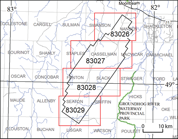
Map 83 026, Map 83 027, Map 83 028, Map 83 029
Airborne Magnetic and Electromagnetic Surveys, Residual Magnetic Field Contours with Electromagnetic Anomalies and Keating Correlation Coefficients, Saganash Lake Area; by Ontario Geological Survey, scale 1:20 000, colour. Map prices range from $13.70 to $15.95.
1:50 000 Scale Map Sheets
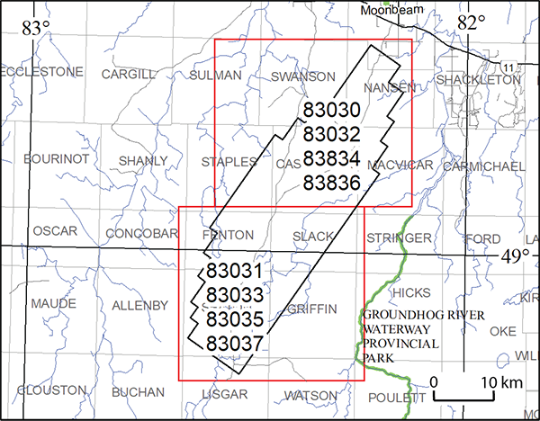
Map 83 030, Map 83 031
Airborne Magnetic and Electromagnetic Surveys, Colour-Filled Contours of the Residual Magnetic Field and Electromagnetic Anomalies, Saganash Lake Area; by Ontario Geological Survey, scale 1:50 000, colour. Map prices range from $11.45 to $11.50.
Map 83 032, Map 83 033
Airborne Magnetic and Electromagnetic Surveys, Shaded Colour Image of the Second Vertical Derivative of the Residual Magnetic Field and Keating Correlation Coefficients, Saganash Lake Area; by Ontario Geological Survey, scale 1:50 000, colour. Map prices range from $11.55 to $11.60.
Map 83 034, Map 83 035
Airborne Magnetic and Electromagnetic Surveys, Colour-Filled Contours of the EM Decay Constant and Electromagnetic Anomalies, Saganash Lake Area; by Ontario Geological Survey, scale 1:50 000, colour. $11.50 each.
Map 83 036, Map 83 037
Airborne Magnetic and Electromagnetic Surveys, Colour-Filled Contours of the Apparent Conductivity and Electromagnetic Anomalies, Saganash Lake Area; by Ontario Geological Survey, scale 1:50 000, colour. Map prices range from $11.50 to $11.55.
Geophysical Data Set
Geophysical Data Set 1089
Ontario Airborne Geophysical Surveys, Magnetic and Electromagnetic Data, Grid and Profile Data (ASCII and Geosoft® Formats) and Vector Data, Saganash Lake Area; by Ontario Geological Survey. The data are available on 1 DVD. $25.00
Airborne Geophysical Survey
Nameigos Lake Area
1:20 000 Scale Map Sheets
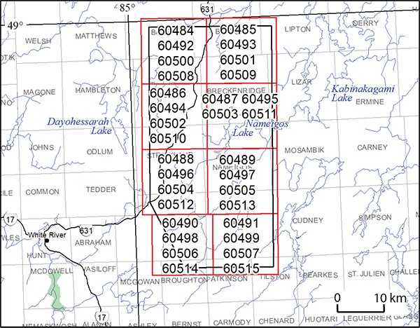
Map 60 484, Map 60 485, Map 60 486, Map 60 487,
Map 60 488, Map 60 489, Map 60 490, Map 60 491
Airborne Magnetic and Gravimetric Surveys, Colour-Filled Contours of the Residual Magnetic Field, Nameigos Lake Area; by Ontario Geological Survey, scale 1:20 000, colour. Map prices range from $11.90 to $12.30.
Map 60 492, Map 60 493, Map 60 494, Map 60 495,
Map 60 496, Map 60 497, Map 60 498, Map 60 499
Airborne Magnetic and Gravimetric Surveys, Shaded Colour Image of the Second Vertical Derivative of the Residual Magnetic Field and Keating Correlation Coefficients, Nameigos Lake Area; by Ontario Geological Survey, scale 1:20 000, colour. Map prices range from $12.20 to $12.60.
Map 60 500, Map 60 501, Map 60 502, Map 60 503,
Map 60 504, Map 60 505, Map 60 506, Map 60 507
Airborne Magnetic and Gravimetric Surveys, Colour-Filled Contours of the Terrain-Corrected Bouguer Gravity, Nameigos Lake Area; by Ontario Geological Survey, scale 1:20 000, colour. Map prices range from $11.70 to $12.30.
Map 60 508, Map 60 509, Map 60 510, Map 60 511,
Map 60 512, Map 60 513, Map 60 514, Map 60 515
Airborne Magnetic and Gravimetric Surveys, Colour-Filled Contours of the First Vertical Derivative of the Terrain-Corrected Bouguer Gravity, Nameigos Lake Area; by Ontario Geological Survey, scale 1:20 000, colour. Map prices range from $11.60 to $12.30.
Geophysical Data Set
Geophysical Data Set 1250
Ontario Airborne Geophysical Surveys, Magnetic and Gravimetric Data, Grid and Profile Data (ASCII and Geosoft® Formats) and Vector Data, Nameigos Lake Area; by Ontario Geological Survey. The data are available on 1 DVD. $25.00
Airborne Geophysical Survey
Mozhabong Lake Area
1:20 000 Scale Map Sheets
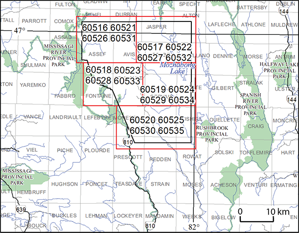
Map 60 516, Map 60 517, Map 60 518, Map 60 519, Map 60 520
Airborne Magnetic and Gravimetric Surveys, Colour-Filled Contours of the Residual Magnetic Field, Mozhabong Lake Area; by Ontario Geological Survey, scale 1:20 000, colour. Map prices range from $12.20 to $13.75.
Map 60 521, Map 60 522, Map 60 523, Map 60 524, Map 60 525
Airborne Magnetic and Gravimetric Surveys, Shaded Colour Image of the Second Vertical Derivative of the Residual Magnetic Field and Keating Correlation Coefficients, Mozhabong Lake Area; by Ontario Geological Survey, scale 1:20 000, colour. Map prices range from $12.95 to $14.80.
Map 60 526, Map 60 527, Map 60 528, Map 60 529, Map 60 530
Airborne Magnetic and Gravimetric Surveys, Colour-Filled Contours of the Terrain-Corrected Bouguer Gravity, Mozhabong Lake Area; by Ontario Geological Survey, scale 1:20 000, colour. Map prices range from $12.40 to $14.05.
Map 60 531, Map 60 532, Map 60 533, Map 60 534, Map 60 535
Airborne Magnetic and Gravimetric Surveys, Colour-Filled Contours of the First Vertical Derivative of the Terrain-Corrected Bouguer Gravity, Mozhabong Lake Area; by Ontario Geological Survey, scale 1:20 000, colour. Map prices range from $12.20 to $13.75.
Geophysical Data Set
Geophysical Data Set 1251
Ontario Airborne Geophysical Surveys, Magnetic and Gravimetric Data, Grid and Profile Data (ASCII and Geosoft® Formats) and Vector Data, Mozhabong Lake Area; by Ontario Geological Survey. The data are available on 1 DVD. $25.00
Errata and Amendments
On Preliminary Map P.3841, Precambrian Geology of Kenogaming Township, Northern Swayze Area, Abitibi Greenstone Belt, Northeastern Ontario, originally released November 2019 and updated December 2020, an incorrect reference was cited for the age of the Matchewan dike swarm in footnote “f” of the Legend. The correct reference should be Bleeker et al. (2015), not Heaman (1988). Additionally, Heaman (1988) should not have been included in the list of Geochronology references under “Sources of Information”. Additionally, the reference regarding corresponding and additional digital data related to the map has been updated to reflect the fact that Miscellaneous Release—Data 378, Geological, Geochemical and Geophysical Data Related to Penhorwood and Kenogaming Townships, Northern Swayze Area, Abitibi Greenstone Belt, Northeastern Ontario, was revised in 2021.
On Preliminary Map P.3842, Precambrian Geology of Penhorwood Township, Northern Swayze Area, Abitibi Greenstone Belt, Northeastern Ontario, originally released December 2020, an incorrect reference was cited for the age of the Matchewan dike swarm in footnote “f” of the Legend. The correct reference should be Bleeker et al. (2015a), not Heaman (1988). In the list of Geochronology references, under “Sources of Information”, Heaman (1988) should not have been included. Additionally, the first Bleeker et al. reference should be “2015a”, and the second, “2015b”. In Table 1, for sample no.5, the reference should be Bleeker et al. (2015b), not “Bleeker et al. (2015)”. Additionally, the reference regarding corresponding and additional digital data related to the map has been updated to reflect the fact that Miscellaneous Release—Data 378, Geological, Geochemical and Geophysical Data Related to Penhorwood and Kenogaming Townships, Northern Swayze Area, Abitibi Greenstone Belt, Northeastern Ontario, was revised in 2021.
New versions of these maps are available. If you purchased a copy of these maps prior to 2021 and wish to receive replacement copies, please contact Publication Sales, and new versions will be shipped to you free of charge. Alternatively, the new versions of Preliminary Map P.3841 and Preliminary Map P.3842 are available for free downloading on GeologyOntario.
We regret any inconvenience these errors and amendments may have caused.
Location Map (PDF)
Amendments
Over the years, the Ontario Geological Survey (OGS) has included third-party applications in some of its data products. Because of the difficulty in maintaining these publications with every new update of these applications, the OGS has decided to remove such applications from its publications.
Several digital data publications, released during the period between 2006 and 2016, contain files related to a viewer that requires the use of the Microsoft® Virtual Earth® application programming interface (API). The OGS has removed the viewer from these publications and updated other affected files.
Specifically, these publications have been updated to 1) modify or remove movie files; 2) remove related data files; and 3) update accompanying documentation to remove references to the viewer. The following publications, with listed changes, have been updated.
- In Miscellaneous Release—Data (MRD) 207, Bedrock Topography and Overburden Thickness Mapping, Southern Ontario (released December 12, 2006), the movie (.avi) file, “viewer” folder and data files have been removed; and the readme and metadata (.pdf) documents modified to remove references to the viewer.
- In Groundwater Resources Study (GRS) 3, Three-Dimensional Mapping of Surficial Deposits in the Regional Municipality of Waterloo, Southwestern Ontario (released August 7, 2007), the movie (.avi) file has been modified to remove the demonstration of the cross-section viewer; the “Section Viewer” folder and data files removed; and the readme, report and metadata (.pdf) documents modified to remove references to the cross-section viewer.
- In Groundwater Resources Study (GRS) 10, Three-Dimensional Mapping of Surficial Deposits in the Brantford–Woodstock Area, Southwestern Ontario (released August 3, 2011), the movie (.avi) file has been modified to remove the demonstration of the cross-section viewer; the “Section Viewer” folder and data files removed; and the readme, report and metadata (.pdf) documents modified to remove references to the cross-section viewer.
- In Groundwater Resources Study (GRS) 11, Three-Dimensional Modelling of Surficial Deposits in the Barrie–Oro Moraine Area of Southern Ontario (released November 8, 2011), the movie (.avi) file has been modified to remove the demonstration of the cross-section viewer; the “Section Viewer” folder and data files removed; and the readme, report and metadata (.pdf) documents modified to remove references to the cross-section viewer.
- In Groundwater Resources Study (GRS) 15, Three-Dimensional Modelling of Surficial Deposits in the Orangeville–Fergus Area of Southern Ontario (released April 27, 2016), the movie (.avi) file has been modified to remove the demonstration of the cross-section viewer; the “Section Viewer” folder and data files removed; and the readme, report and metadata (.pdf) documents modified to remove references to the cross-section viewer.
The updated versions of these data publications are available. If you purchased a CD or DVD of any of these data publications and wish to receive a replacement copy, please contact Publication Sales, and the updated version will be shipped to you free of charge. Alternatively, the updated versions of Miscellaneous Release—Data 207, Groundwater Resources Study 3, Groundwater Resources Study 10, Groundwater Resources Study 11 and Groundwater Resources Study 15 are available for free downloading on GeologyOntario.
Similar changes for other publications may be announced as required.
We regret any inconvenience this issue may have caused.
Earth Resources and Geoscience Mapping Section
Precambrian Geology – Far North
Preliminary Map P.3829
Precambrian Geology of the Wabassi River Area, Fort Hope–Miminiska Greenstone Belt, Northwestern Ontario; by B. Azar, M.N. Hakimian and K. Zammit, scale 1:100 000, colour. Geochemical, geophysical and geological data available as Miscellaneous Release—Data 389 (see below). $14.05
Preliminary Map P.3843
Precambrian Geology of the Makokibatan Lake Area, Fort Hope–Miminiska Greenstone Belt, Northwestern Ontario–West Sheet; by B. Azar and J.R. Bellrose, scale 1:50 000, colour. Geological, geochemical and geophysical data available as Miscellaneous Release—Data 380 (see below). $14.85
Preliminary Map P.3844
Precambrian Geology of the Makokibatan Lake Area, Fort Hope–Miminiska Greenstone Belt, Northwestern Ontario–East Sheet; by B. Azar and J.R. Bellrose, scale 1:50 000, colour. Geological, geochemical and geophysical data available as Miscellaneous Release—Data 380 (see below). $17.25
Miscellaneous Release—Data 380
Geological, Geochemical and Geophysical Data Related to the Makokibatan Lake Area, Fort Hope–Miminiska Greenstone Belt, Northwestern Ontario; by B. Azar. This digital data release consists of geochemical data, magnetic susceptibility data, geological information, structural data and selected field photographs for the Makokibatan Lake area of the Fort Hope–Miminiska greenstone belt, which were collected during the 2016 field season and a three-week period in 2017. This release contains whole-rock geochemistry (major element, trace element, rare earth element), assay data and quality control information, magnetic susceptibility data, drill hole data and field notes. These data augment the associated Preliminary Maps P.3843, Precambrian Geology of the Makokibatan Lake Area, Fort Hope–Miminiska Greenstone Belt, Northwestern Ontario–West Sheet; and P.3844, Precambrian Geology of the Makokibatan Lake Area, Fort Hope–Miminiska Greenstone Belt, Northwestern Ontario–East Sheet. The shared marginal notes and geological legend from these Preliminary Maps are also provided and are available as 2 separate portable document format (.pdf) files. Additional information includes the associated Summary of Field Work and Other Activities article from 2016; and a poster and presentation that were presented at the 2017 Ontario Prospectors Exploration Showcase (OPES) in Thunder Bay, Ontario, available as portable document format (.pdf) files. Location data are provided in the Universal Transverse Mercator (UTM) projection and grid system, North American Datum 1983 (NAD83), Zone 16. This release consists of 5 Microsoft® Excel® for Office 365 (.xlsx) format files, 190 photographs (.jpg format files) and 8 portable document format (.pdf) files. The data are available on 1 CD. $20.00
Miscellaneous Release—Data 389
Geochemical, Geophysical and Geological Data Related to the Wabassi River Area, Fort Hope–Miminiska Greenstone Belt, Northwestern Ontario; by B. Azar. This digital data release consists of geochemical data, magnetic susceptibility data, geological information, structural data and selected field photographs for the Fort Hope–Miminiska greenstone belt in the Peninsular Lake area, which were collected during the 2017 field season. This release contains whole-rock geochemistry (major element, trace element, rare earth element), quality control information, magnetic susceptibility data, drill hole data and field notes. These data are associated with Preliminary Map P.3849, Precambrian Geology of the Peninsular Lake Area, Fort Hope–Miminiska Greenstone Belt, Northwestern Ontario; the marginal notes and the geological legend (as 2 portable document format (.pdf) files) from the Preliminary Map are also provided. Additional information includes the associated Summary of Field Work and Other Activities article from 2017. Location data are provided in the Universal Transverse Mercator (UTM) projection and grid system, Zone 16, North American Datum 1983 (NAD83). This release consists of 5 Microsoft® Excel® for Office 365 (.xlsx) format files; 103 photographs (.jpg format files) and 5 portable document format (.pdf) files. The data are available on 1 CD. $20.00
Aggregate Resources and Industrial Minerals
Aggregate Resources of Ontario ARO—2020
The Ontario Geological Survey (OGS) is releasing a GIS-based compilation of the aggregate resources of Ontario. This compilation, updated in June 2021, is based on data compiled from aggregate resources inventory mapping conducted by the OGS from 1980 to 2020. It is intended that this compilation will be updated annually. This compilation includes data updated from the previously published information and may include newer geological data and/or mapping, where the latter are available.
It is important to note that this compilation is not intended to be used as a standalone product and the referenced original reports should always be consulted in conjunction with this compilation. Information contained within the referenced original reports (i.e., test results, resource properties and potential) is still highly relevant. However, it is possible that resource estimates provided in the referenced original reports may no longer be accurate, and may not reflect the data contained in this compilation. It must also be noted that, although the data represented in this compilation have been modified and updated since the release of the previously published information, the referenced original publications have not been revised to incorporate these changes.
The Aggregate Resources of Ontario—2020 (or ARO–2020) is available as a direct download from OGSEarth. The compressed (.zip) download file provides ARO–2020 data in geodatabase format using ESRI® ArcGIS® 9.3.1 with a completed project file (.mxd). Geospatial data are provided in North American Datum 1983 (NAD83) geographic co-ordinate system using decimal degrees. A user document and readme file that explains the GIS content is provided.
Groundwater Studies
Miscellaneous Release—Data 390
Groundwater Hydrochemistry, Water Isotope and Manual Water-Level Data for the Early Silurian Carbonates of the Niagara Escarpment Cuesta; by E.H. Priebe. This digital data release presents the results of groundwater sampling conducted in the summer of 2016, during which 69 groundwater samples were collected from 12 multidepth monitoring wells, 5 provincial groundwater monitoring network wells and 19 domestic wells. All sampled wells are installed in the bedrock aquifers of the Early Silurian carbonates of the Niagara Escarpment cuesta of southern Ontario. This digital data release includes the raw hydrochemistry and isotope geochemistry data, as well as a description of sampling locations, sampling and analysis methods, and quality-control measures. Accuracy and precision plots and the data used to create them are provided in a supporting portable document format (.pdf) document and a Microsoft® Excel® for Office 365 (.xlsx) file, respectively. The data are available on 1 CD. $20.00
Location Map (PDF)
Earth Resources and Geoscience Mapping Section
Precambrian Geology – Far North
Preliminary Map P.3849
Precambrian Geology of the Peninsular Lake Area, Fort Hope–Miminiska Greenstone Belt, Northwestern Ontario; by B. Azar, K. Zammit and M.N. Hakimian, Geochemical, geophysical and geological data available as Miscellaneous Release—Data 394 (see below). scale 1:50 000, colour. $13.10
Miscellaneous Release—Data 394
Geological, Geochemical and Geophysical Data from the Peninsular Lake Area, Fort Hope–Miminiska Greenstone Belt, Northwestern Ontario; by B. Azar. This digital data release consists of geochemical data, magnetic susceptibility data, geological information, structural data and selected field photographs for the Fort Hope–Miminiska greenstone belt in the Peninsular Lake area, which were collected during the 2017 field season. This release contains whole-rock geochemistry (major element, trace element, rare earth element), quality control information, magnetic susceptibility data, drill hole data and field notes. These data are associated with Preliminary Map P.3849, Precambrian Geology of the Peninsular Lake Area, Fort Hope–Miminiska Greenstone Belt, Northwestern Ontario; the marginal notes and the geological legend (as 2 portable document format (.pdf) files) from the Preliminary Map are also provided. Additional information includes the associated Summary of Field Work and Other Activities article from 2017. Location data are provided in the Universal Transverse Mercator (UTM) projection and grid system, Zone 16, North American Datum 1983 (NAD83). This release consists of 5 Microsoft® Excel® for Office 365 (.xlsx) files; 103 photographs (.jpg format files) and 5 portable document format (.pdf) files. The data are available on 1 CD. $20.00
Location Map (PDF)
Earth Resources and Geoscience Mapping Section
Precambrian Geology — Northwestern Ontario
Preliminary Map P.3845
Precambrian Geology of Priske Township, Northwestern Ontario; by S.J. Magnus, scale 1:20 000, colour. Geological, geochemical, petrographic and isotopic data available as Miscellaneous Release—Data 381 (see below). $16.25
Preliminary Map P.3846
Precambrian Geology of Strey Township, Northwestern Ontario; by E.C.G. Hastie and S.J. Magnus, scale 1:20 000, colour. Geological, geochemical and petrographic data available as Miscellaneous Release—Data 382 (see below). $13.10
Miscellaneous Release—Data 381
Geological, Geochemical and Petrographic Data from Priske Township and Nd, Sm and Sr Isotopic Data from Priske, Strey, Syine, Tuuri and Walsh Townships, Western Schreiber–Hemlo Greenstone Belt, Wawa–Abitibi Terrane, Superior Province, Northwestern Ontario; by S.J. Magnus. This data release includes geological, whole rock geochemical and petrographic data collected primarily in Priske Township, with a small number of additional samples from Strey and Killraine townships and the Pays Plat Lake and Lower Aguasabon Lake areas, as part of a 4-year (2015–2018), 1:20 000 scale bedrock mapping project in the Schreiber–Hemlo greenstone belt. This release also includes Nd, Sm and Sr isotopic data collected from Archean and Proterozoic bedrock in Priske, Strey, Syine, Tuuri and Walsh townships, which encompass the entire western part of the Neoarchean Schreiber–Hemlo greenstone belt. The project was undertaken to 1) update knowledge of the local Archean and Proterozoic geology using modern mapping, geochemical and geochronological techniques, and 2) produce an updated genetic model for the greenstone belt that may be used as a framework for more detailed academic and mineral exploration activities. These data augment Preliminary Map P.3845, Precambrian Geology of Priske Township, Northwestern Ontario; the legend and marginal notes for this map are also provided. This release comprises 54 photographs (as .jpg files), 4 Microsoft® Excel® for Office 365 (.xlsx) workbook files and 8 documents in portable document format (.pdf). The data are available on 1 CD. $20.00
Miscellaneous Release—Data 382
Geological, Geochemical and Petrographic Data from Strey Township, Western Schreiber–Hemlo Greenstone Belt, Wawa–Abitibi Terrane, Superior Province, Northwestern Ontario; by E.C.G. Hastie and S.J. Magnus. This data release includes geological, whole rock geochemical and petrographic data collected in Strey Township as part of a 4-year (2015–2018), 1:20 000 scale bedrock mapping project in the Schreiber–Hemlo greenstone belt. The project was undertaken to 1) update knowledge of the local Archean and Proterozoic geology using modern mapping, geochemical and geochronological techniques, and 2) produce an updated genetic model for the greenstone belt that may be used as a framework for more detailed academic and mineral exploration activities. These data augment Preliminary Map P.3846, Precambrian Geology of Strey Township, Northwestern Ontario; the legend for this map is also provided. This release comprises 3 Microsoft® Excel® for Office 365 (.xlsx) workbook files and 6 documents in portable document format (.pdf). The data are available on 1 CD. $20.00
Resident Geologist Program
Open File Report 6371
Report of Activities 2020, Resident Geologist Program, Red Lake Regional Resident Geologist Report: Red Lake and Kenora Districts; by S.O. Lewis, M. Dorado-Troughton, C. Ravnaas, S.A. Ferguson, T.K. Pettigrew, G. Dorland and C. Patterson, 95p. $10.60
Open File Report 6372
Report of Activities 2020, Resident Geologist Program, Thunder Bay North Regional Resident Geologist Report: Thunder Bay North District; by T.K. Pettigrew, G.F. Paju, M. Dorado-Troughton, S.A. Ferguson, G. Dorland and C. Patterson, 63p. $9.55
Open File Report 6373
Report of Activities 2020, Resident Geologist Program, Thunder Bay South Regional Resident Geologist Report: Thunder Bay South District; by D.A. Campbell, M. Dorado-Troughton, T.K. Pettigrew, S.A. Ferguson, G. Dorland and C. Patterson, 95p. $10.85
Open File Report 6374
Report of Activities 2020, Resident Geologist Program, Timmins Regional Resident Geologist Report: Timmins and Sault Ste. Marie Districts; by Z. Azadbakht, P. Bousquet, K. Zammit, C.M. Daniels, S.L.K. Hinz, P. Sword, C. Boucher, G. Dorland and C. Patterson, 114p. $10.25
Open File Report 6375
Report of Activities 2020, Resident Geologist Program, Kirkland Lake Regional Resident Geologist Report: Kirkland Lake and Sudbury Districts; by P.J. Chadwick, A.S. Péloquin, J. Suma-Momoh, C.M. Daniels, S.L.K. Hinz, G. Dorland, C. Patterson and R.M. Todd, 157p. $11.75
Open File Report 6376
Report of Activities 2020, Resident Geologist Program, Southern Ontario Regional Resident Geologist Report: Southeastern and Southwestern Ontario Districts and Petroleum Operations; by L.A. Mancini, R.D. Meek, N. Sabiri, P.S. LeBaron, L.M. Rodriguez Miguel, S.L.K. Hinz, G. Dorland, C. Patterson and L. Fortner, 67p. $9.35
Errata
In Open File Report 6323, Summary of Field Work and Other Activities 2016 (released December 20, 2016), in Article 18, Metasomatism, Syenite Magmatism and Rare Earth Element and Related Metallic Mineralization in Bancroft and Frontenac Terranes: A Preliminary Deposit Model, there are errors in the locations for the outcrops shown in 3 photographs. The specific captions, with corrected UTM co-ordinates shown in bold, are as follows.
- caption for Photo 18.1A (page 18-3): “A) Large, irregular, near-vertical pink calcite vein (just to the left of and above the scintillometer) cuts medium-grained pyroxene syenite; observed on the north side of Highway 60 east of Eganville. Scintillometer (yellow-white-black, lower centre) is 23 cm long; screen is 10 cm square. (Cobden area: 339600E 5046090N).”
- captions for Photos 18.2C and 18.2D (page 18-4): “C) Coarse-grained blue-green apatite and biotite from the core of a 110 cm wide mica pyroxenite and apatite vein cutting feldspathic paragneiss on the south side of Kenyon Road (402030E 4966039N). D) Coarse-grained mica pyroxenite from the same vein as Photo 18.2C. The mica pyroxenite is marginal to apatite-mica rock that forms the core of the vein (402030E 4966039N).”
These errors have been corrected. You may download the corrected version of Open File Report 6323 from our GeologyOntario Web site.
We regret any inconvenience these errors may have caused.
Location Map (PDF)
Announcement
The Ontario Geological Survey (OGS) is looking to purchase proprietary airborne geophysical survey data from private-sector companies to enhance its current inventory. These data will be put into the public domain to encourage mineral exploration and support economic recovery. Through this request for data, the Ministry of Energy, Northern Development and Mines will solicit, evaluate, and may choose to purchase privately owned airborne geophysical data (survey data) that meet both OGS quality standards and program objectives. You can review or download the complete Request for Data from the Ministry's Web site.
Earth Resources and Geoscience Mapping Section
Precambrian Geology – Northwestern Ontario
Miscellaneous Release—Data 308 – Revised
New and Compiled Whole-Rock Geochemical and Isotope Data of Midcontinent Rift–Related Rocks, Thunder Bay Area; by R.M. Cundari, M.A. Puumala, M.C. Smyk and P. Hollings. This digital data release is an update of the Midcontinent Rift geochemical database released in 2013 as Miscellaneous Release—Data (MRD) 308. MRD 308—Revised includes new whole-rock and trace element analyses for 124 bedrock samples of mafic igneous rocks related to the Mesoproterozoic Midcontinent Rift. The release also includes a compilation of geochemical data for Midcontinent Rift–related rocks from the following previously released digital data sets: MRDs 114, 132, 133, 146, 147, 190, 261—Revised, 308, 319, 345, 352 and 368. The historical compilation includes 2821 spatially referenced data points with geochemical analyses. Additionally, 132 samples with Rb, Sr, Nd, Sm and/or εNd isotopic data are also included in this release, compiled from various sources. The compilation of data and a brief overview of the referenced MRDs and analytical procedures are presented as 2 Microsoft® Excel® for Office 365 (.xlsx) and 2 portable document format (.pdf) files. The data are available on 1 CD. $20.00
Surficial Geochemistry
Miscellaneous Release—Data 322 – Revised
Indicator Mineral and Geochemistry Data for the Till and Alluvium Sampling Survey in the McFaulds Lake (“Ring of Fire”) Area, Northern Ontario; by C. Gao, D.C. Crabtree, R.D. Dyer and S.A. Clarke. This digital data release is a revision of Miscellaneous Release—Data (MRD) 322, which was published in 2016. These digital data present the results of a regional till and modern alluvium sampling survey in the McFaulds Lake (“Ring of Fire”) area, in northern Ontario. The samples were collected during the summer field seasons between 2011 and 2015. The data consist of indicator mineral grain counts, geochemical and compositional data of kimberlite indicator minerals (KIMs), chromite, metamorphic/magmatic massive sulphide indicator minerals (MMSIM®*), and gold grains recovered from till and river sand and gravel (alluvium) samples. In addition, this revised version provides bulk mineralogy of fine-fraction, 0.125–0.25 mm nonmagnetic heavy mineral concentrates; proportional dot maps of the spatial distribution of the fine-fraction detrital chromite grains; and an expanded microprobe data of detrital chromite grains, including those from sand- to pebble-size chromitite clasts. The files contain specific information on sample site locations, sample processing data, KIMs picked and picking remarks, electron probe microanalyzer results of KIM and chromite grains, adjusted KIM results, gold grain data, MMSIM® data, clastic lithology data and geochemical data from the <0.063 mm fraction of the bulk samples, as well as the spatial distribution of the fine-fraction detrital chromite grains and photomicrographs of the chromitite clasts. These data supplement Open File Report (OFR) 6309 (available separately), providing the data generated during the study. In this release, Appendix 8 has been revised; however, Appendixes 18, 19 and 20 provide new data and are not discussed in OFR 6309. This release comprises 19 Microsoft® Excel® for Office 365 (.xlsx) files, 20 backscattered electron images (.tif files) and 3 documents in portable document format (.pdf). The data are available on 1 CD. $20.00
[*MMSIM is a registered trademark of Overburden Drilling Management Limited, Nepean, Ontario.]
Miscellaneous
The Ministry of Northern Development and Mines has prepared supplements for Miscellaneous Papers (MP) 177 and 178 to include publications released in 2020. Also, the Bedrock Geology Index to Maps and Surficial Geology Index to Maps are updated to include all maps released in 2020. Miscellaneous Paper 177 (Supplement 2011–2020), MP 178 (Supplement 2011–2020) and the maps are available as free downloads or can be purchased in hard-copy format from Publication Sales.
Miscellaneous Paper (MP) 177 (Supplement 2011–2020)
Index to Published Reports, Maps and Digital Data, 2011–2020
This report provides a listing of all publications released since the publication of MP 177 (Supplement 1993–2010), Index to Published Reports, Maps and Digital Data, 1993–2010. Publications are listed by series only. 225p. $9.90
Miscellaneous Paper (MP) 178 (Supplement 2011–2020)
Geographic Index to Published Reports, Maps and Digital Data, 2011–2020
This report provides a listing of all publications released since the publication of MP 178 (Supplement 1994–2010), Geographic Index to Published Reports, Maps and Digital Data, 1994–2010. Publications are indexed by geographic areas, which include National Topographic System (NTS) areas, geographic townships and Ministry of Natural Resources (MNR) “areas”. Publications are listed under the main geographic areas where they are located. 924p. $14.80
Index to Maps, Bedrock Geology, 1991–2020; produced by the Publication Services Unit, scale 1:1 000 000, colour. Available as a set of 4 maps. $12.00
Index to Maps, Surficial Geology, 1991–2020; produced by the Publication Services Unit, scale 1:1 000 000, colour. Available as a set of 4 maps. $12.00
Location Map (PDF)
Earth Resources and Geoscience Mapping Section
Precambrian Geology — Northeastern Ontario
Preliminary Map Series P3847
Precambrian Geology of Reeves Township, Northern Swayze Area, Abitibi Greenstone Belt, Northeastern Ontario; by L.E.D. Vice and P.J. MacDonald, scale 1:20 000, colour. Geological, geochemical and geophysical data available as Miscellaneous Release—Data 393 (see below). $13.25
Preliminary Map Series P3848
Precambrian Geology of Sewell Township, Northern Swayze Area, Abitibi Greenstone Belt, Northeastern Ontario; by L.E.D. Vice and P.J. MacDonald, scale 1:20 000, colour. Geological, geochemical and geophysical data available as Miscellaneous Release—Data 393 (see below). $13.00
Miscellaneous Release—Data 393
Geological, Geochemical and Geophysical Data Related to Reeves and Sewell Townships, Northern Swayze area, Abitibi Greenstone Belt, Northeastern Ontario; by L.E.D. Vice and P.J. MacDonald. This digital data release contains field data, field photographs, whole-rock geochemical data, geochronology information, and magnetic susceptibility data related to 1:20 000 scale mapping of Reeves and Sewell townships, along with parts of Muskego and Melrose townships, northeastern Swayze area collected during the summers of 2018 and 2019. Also included is the previously published Summary of Field Work and Other Activities article related to the project. This release comprises 104 photographs (as .jpg files), 8 Microsoft® Excel® for Office 365 (.xlsx) workbook files and 5 documents in portable document format (.pdf). These data augment Preliminary Maps P.3847, Precambrian Geology of Reeves Township, Northern Swayze Area, Abitibi Greenstone Belt, Northeastern Ontario, and P.3848, Precambrian Geology of Sewell Township, Northern Swayze Area, Abitibi Greenstone Belt, Northeastern Ontario; the geological legend for the maps is also provided. The data are available on 1 CD. $20.00
Precambrian Geology — Northwestern Ontario
Miscellaneous Release—Data 391
Geochemical Data from Graphitic Metasedimentary Rocks of the Shebandowan Greenstone Belt, Northwestern Ontario; by M.A. Puumala. This digital data release includes geochemical data collected as part of a project to study the geochemistry of altered graphitic and exhalative metasedimentary rock from various locations in the Shebandowan greenstone belt located west-northwest of the city of Thunder Bay. A total of 85 samples were collected between 2017 and 2019 by staff of the Thunder Bay Resident Geologist Program Office. In addition, 3 samples collected from the Schreiber–Hemlo greenstone belt (an area where future sampling is planned) are also included with this data set. This release comprises 1 Microsoft® Excel® for Office 365 (.xlsx) workbook file and 8 documents in portable document format (.pdf). The data are available on 1 CD. $20.00
Aggregate Resources and Industrial Minerals
Aggregate Resources of Ontario ARO—2020
The Ontario Geological Survey (OGS) is releasing a GIS-based compilation of the aggregate resources of Ontario. This compilation is based on data compiled from aggregate resources inventory mapping conducted by the OGS from 1980 to 2020. It is intended that this compilation will be updated annually. This compilation includes data updated from the previously published information and may include newer geological data and/or mapping, where the latter are available.
It is important to note that this compilation is not intended to be used as a standalone product and the referenced original reports should always be consulted in conjunction with this compilation. Information contained within the referenced original reports (i.e., test results, resource properties and potential) is still highly relevant. However, it is possible that resource estimates provided in the referenced original reports may no longer be accurate, and may not reflect the data contained in this compilation. It must also be noted that, although the data represented in this compilation have been modified and updated since the release of the previously published information, the referenced original publications have not been revised to incorporate these changes.
The Aggregate Resources of Ontario—2020 (or ARO—2020) is available as a direct download from OGSEarth. The compressed (.zip) download file provides ARO—2020 data in geodatabase format using ESRI® ArcGIS® 9.3.1 with a completed project file (.mxd). Geospatial data are provided in North American Datum 1983 (NAD83) geographic co-ordinate system using decimal degrees. A user document and readme file that explains the GIS content is provided.
Location Map (PDF)
2020 Publications
Earth Resources and Geoscience Mapping Section
Precambrian Geology — Northeastern Ontario
Preliminary Map P.3842
Precambrian Geology of Penhorwood Township, Northern Swayze Area, Abitibi Greenstone Belt, Northeastern Ontario; by P.J. MacDonald, L.E.D. Vice and J.M. Bisaillon, scale 1:20 000, colour. Geological, geochemical and geophysical data available as Miscellaneous Release—Data 378 (see below). $13.75
Miscellaneous Release—Data 378
Geological, Geochemical and Geophysical Data Related to Penhorwood and Kenogaming Townships, Northern Swayze Area, Abitibi Greenstone Belt, Northeastern Ontario; by L.E.D. Vice and P.J. MacDonald. This digital data release contains field data, field photographs, whole-rock geochemical data, geochronology information, and magnetic susceptibility data related to 1:20 000 scale mapping of Penhorwood and Kenogaming townships, along with parts of Pharand and Regan townships, northeastern Swayze area collected during the summer of 2018. Also included are previously published Summary of Field Work and Other Activities articles related to the project. This release comprises 192 photographs (as .jpg files), 8 Microsoft® Excel® for Office 365 (.xlsx) workbook files and 7 documents in portable document format (.pdf). These data augment Preliminary Maps P.3842, Precambrian Geology of Penhorwood Township, Northern Swayze Area, Abitibi Greenstone Belt, Northeastern Ontario, and P.3841, Precambrian Geology of Kenogaming Township, Northern Swayze Area, Abitibi Greenstone Belt, Northeastern Ontario; the geological legend for the maps is also provided. The data are available on 1 CD. $20.00
Precambrian Geology — Northwestern Ontario
Miscellaneous Release—Data 387
Compilation of Soil, Rock and Lake Sediment Sampling Data from the Red Lake Area, Northwestern Ontario; compiled by S.O. Lewis. This digital data release includes all of the soil, rock and lake sediment geochemical data collected by Laurentian Goldfields Ltd. (now PureGold Mining Inc.), from 2011 to 2012, at their Goldpines North and Goldpines South properties. The 4287 soil samples, 214 whole-rock samples, and 144 lake sediment samples were collected from an approximately 163 km2 area in the Ear Falls area southeast of Red Lake, Ontario. These data were compiled from assessment files AFRI# 20000007485, 20000007991 and 2000008062. The analytical, quality assurance and quality control details can be found in the respective assessment file. All sample locations are provided using North American Datum 1983 (NAD83) in Zone 15. This release comprises 3 Microsoft® Excel® for Office 365 (.xlsx) workbook files and 1 document in portable document format (.pdf). The data are available on 1 CD. $20.00
Surficial Mapping and Sampling
Miscellaneous Release—Data 383
Results of the 2014–2017 Drilling Programs on the Niagara Peninsula: Graphic Logs, Descriptions and Analytical Data; by A.K. Burt. This release contains graphic logs, sediment descriptions, interpretations, analytical data, a subsurface database and photographs resulting from 99 continuously cored boreholes drilled as part of the multiyear, Niagara Peninsula three-dimensional (3-D) sediment mapping project. The data in this release can be used as a geologic framework for interpreting lower quality data (i.e., water well records) surrounding each borehole and to calculate the hydraulic conductivity of borehole sediments. The goal of the multiyear mapping project is to build a regional-scale 3-D model of Quaternary deposits that form both regional and local aquifers and aquitards in a region encompassing approximately 5000 km2 of the Niagara Peninsula in southern Ontario. The model will be used for land-use planning purposes and to generate groundwater flow models. This release comprises 18 590 photographs (as .jpg files), 6 Microsoft® Excel® for Office 365 (.xlsx) workbook files, 99 graphic logs (.png), 9 reference maps (.tif), a shapefile of borehole locations and 3 documents in portable document format (.pdf). The data are available on 1 DVD. $25.00
Paleozoic Geology and Energy Studies
Open File Report 6362
Application of Subsurface Mapping to the Interpretation of Paleozoic Structures from Lineament Analysis of High-Resolution Aeromagnetic Data in the Chatham Sag, Southwestern Ontario; by C. Béland Otis, 171p. $15.35
Miscellaneous
Open File Report 6370
Summary of Field Work and Other Activities, 2020; by Ontario Geological Survey, 182p. $11.70
The Contents may be viewed on the Summary of Field Work and Other Activities, 2020 Web page.
Amendments
Preliminary Map P.3841, Precambrian Geology of Kenogaming Township, Northern Swayze Area, Abitibi Greenstone Belt, Northeastern Ontario (released December 2019), has been updated to correct a geochronology age associated with the Matachewan Dike Swarm (unit 28). It should be 2460 Ma. A new geochronology sample (18LV190) has been added to the map and Table 1. Additionally, the location map, and text in the legend footnotes and in “Sources of Information” have been updated to align with those in adjacent map P.3842, published December 2020, and maps P.3847 and P.3848, to be published in 2021. The grey colour of unit 7 (chemical metasedimentary rocks) was also darkened to align with that used on the abovementioned maps.
A new version of this map is available. If you purchased a copy of this map and wish to receive a replacement copy, please contact Publication Sales, and the new version will be shipped to you free of charge. Alternatively, the new version of Preliminary Map P.3841 is available for free downloading on GeologyOntario.
We regret any inconvenience these errors may have caused.
Location Map (PDF)
Earth Resources and Geoscience Mapping Section
Groundwater Studies
Groundwater Resources Study 13
Early Silurian Sequence Stratigraphy and Geological Controls on Karstic Bedrock Groundwater-Flow Zones, Niagara Escarpment Region and the Subsurface of Southwestern Ontario; by F.R. Brunton and C. Brintnell. This digital product comprises a regional outcrop and subsurface study of the early Silurian Lockport Group in southwestern Ontario, western New York State and Michigan, covering an area of 170 000 km2. The study involved the development of protocols for investigating groundwater-flow zones in Silurian sedimentary dolostone caprocks that make up the Niagara Escarpment and cuesta. A key element of the borehole investigations within the potable ground water region of the Niagara Escarpment and cuesta was the integration of optical and acoustic televiewer logs with gamma-ray logs to 1) improve regional stratigraphic pick criteria at formational rank; 2) improve subsurface karst identification; and 3) provide gamma-ray log profiles that highlight the stratigraphic complexity of the Lockport Group for comparison with deeper subsurface oil and gas well data. The study includes data compiled by Candace Brintnell for her Honours BSc and MSc theses at Western University, London, Ontario. The study addresses the historical challenges of the varied nomenclature applied to these early Silurian stack dolostones in Ontario and neighbouring USA states surrounding the Great Lakes region. Type sections are selected and described for the Eramosa and Guelph formations in the City of Guelph. The models for subsurface pinnacle structures are critically assessed relative to the updated stratigraphic nomenclature of the Lockport Group. The report summarizing the results of the study is provided as a portable document format (.pdf) file and is accompanied by 7 appendixes that include stratigraphic sections (.tif) for 346 boreholes and select carbon and oxygen isotopic geochemical profiles. Microsoft® Excel® for Office 365 (.xlsx) tables provide information on the locations of boreholes used in the study. A keyhole markup language zipped file (.kmz) is included that depicts the borehole and outcrop locations used for the creation of the conceptual block models as well as the relative stratigraphic positions of the key karstic bedrock flow zones. The file provides hyperlinks to all borehole logs provided in this study. The data are available on 1 DVD. $25.00
Geophysics
Airborne Geophysical Survey
Biscotasing Area
1:20 000 Scale Map Sheets
Map 83 000, Map 83 001, Map 83 002, Map 83 003, Map 83 004, Map 83 005
Airborne Magnetic and Electromagnetic Surveys, Residual Magnetic Field Contours with Electromagnetic Anomalies and Keating Correlation Coefficients, Biscotasing Area; by Ontario Geological Survey, scale 1:20 000, colour. Map prices range from $13.15 to $15.70.
1:50 000 Scale Map Sheets
Map 83 006, Map 83 007
Airborne Magnetic and Electromagnetic Surveys, Colour-filled Contours of the Residual Magnetic Field and Electromagnetic Anomalies, Biscotasing Area; by Ontario Geological Survey, scale 1:50 000, colour. Map prices range from $13.45 and $12.25.
Map 83 008, Map 83 009
Airborne Magnetic and Electromagnetic Surveys, Shaded Colour Image of the Second Vertical Derivative of the Residual Magnetic Field and Keating Correlation Coefficients, Biscotasing Area; by Ontario Geological Survey, scale 1:50 000, colour. Map prices range from $13.45 and $12.35.
Map 83 010, Map 83 011
Airborne Magnetic and Electromagnetic Surveys, Colour-filled Contours of the EM Decay Constant and Electromagnetic Anomalies, Biscotasing Area; by Ontario Geological Survey, scale 1:50 000, colour. Map prices range from $17.80 and $12.10.
Map 83 012, Map 83 013
Airborne Magnetic and Electromagnetic Surveys, Colour-Filled Contours of the Apparent Conductivity and Electromagnetic Anomalies, Biscotasing Area; by Ontario Geological Survey, scale 1:50 000, colour. Map prices range from $13.20 and $12.10.
Geophysical Data Set
Geophysical Data Set 1087
Ontario Airborne Geophysical Surveys, Magnetic and Electromagnetic Data, Grid and Profile Data (ASCII and Geosoft® Formats) and Vector Data, Biscotasing Area; by Ontario Geological Survey. The data are available on 1 DVD. $25.00
Location Map (PDF)
Earth Resources and Geoscience Mapping Section
Precambrian Geology — Northeastern Ontario
Miscellaneous Release—Data 377
Geological, Geochemical, Geophysical and Geochronological Data Related to Marion and Mallard Townships and Part of Genoa Township, Swayze Area, Southern Abitibi Greenstone Belt; by T.P. Gemmell and N. Szumylo. This digital data release contains field data, field photographs, whole-rock geochemical data, geochronological information, and magnetic susceptibility data related to 1:20 000 scale mapping of the Mallard and Marion townships and part of Genoa Township area in the southeastern Swayze area during the summer of 2018. This release comprises 131 photographs (as .jpg files), 7 Microsoft® Excel® for Office 365 (.xlsx) workbook files and 4 documents in portable document format (.pdf). Also included, in portable document format (.pdf), are 2 previously published Summary of Field Work articles and 1 poster presentation to the public related to the project. These data augment Preliminary Map P.3827, Precambrian Geology of Marion and Mallard Townships and Part of Genoa Township, Southeastern Swayze Area, Abitibi Greenstone Belt, Northeastern Ontario; the geological legend for the map is also provided. The data are available on 1 CD. $20.00
Precambrian Geology — Proterozoic and Grenville Province
Miscellaneous Release—Data 386
Geochemical and Geochronological Data from the Elliot Lake Group and Hough Lake Group of the Huronian Supergroup, Southern Province, Northeastern Ontario; by J.A. Ménard. This digital data release consists of geochronology data, field photographs, scanning electron microscope (SEM) images and whole-rock geochemistry data collected as part of a Huronian Supergroup provenance study of the Sudbury area. This work supports 1:20 000 scale bedrock geological mapping conducted in Denison and Drury townships by the Ontario Geological Survey. This release comprises 51 photographs (as .jpg files), 215 backscattered scanning electron microscope images (as .jpg files), 2 Microsoft® Excel® for Office 365 (.xlsx) files and 7 documents, including 2 presentations, in portable document format (.pdf). The data are available on 1 CD. $20.00
Geophysics
Airborne Geophysical Survey
Sturgeon River Area
1:50 000 Scale Map Sheets
Map 83 014, Map 83 015, Map 83 016, Map 83 017, Map 83 018, Map 83 019
Airborne Magnetic Gradiometer Survey, Colour-Filled Contours of the Residual Magnetic Field, Sturgeon River Area; by Ontario Geological Survey, scale 1:50 000, colour. Map prices range from $12.80 to $13.50.
Map 83 020, Map 83 021, Map 83 022, Map 83 023, Map 83 024, Map 83 025
Airborne Magnetic Gradiometer Survey, Shaded Colour Image of the Second Vertical Derivative of the Residual Magnetic Field and Keating Correlation Coefficients, Sturgeon River Area; by Ontario Geological Survey, scale 1:50 000, colour. Map prices range from $13.30 to $14.20.
Geophysical Data Sets
Geophysical Data Set 1088
Ontario Airborne Geophysical Surveys, Magnetic Gradiometer Data, Grid and Profile Data (ASCII and Geosoft® Formats) and Vector Data, Sturgeon River Area; by Ontario Geological Survey. The data are available on 1 DVD. $25.00
Location Map (PDF)
Earth Resources and Geoscience Mapping Section
Precambrian Geology – Far North
Preliminary Map P.3829
Precambrian Geology of the Wabassi River Area, Fort Hope–Miminiska Greenstone Belt, Northwestern Ontario; by B. Azar, M.N. Hakimian and K. Zammit, scale 1:100 000, colour. Geochemical, geophysical and geological data available as Miscellaneous Release—Data 389 (see below). $14.05
Preliminary Map P.3843
Precambrian Geology of the Makokibatan Lake Area, Fort Hope–Miminiska Greenstone Belt, Northwestern Ontario–West Sheet; by B. Azar and J.R. Bellrose, scale 1:50 000, colour. Geological, geochemical and geophysical data available as Miscellaneous Release—Data 380 (see below). $14.85
Preliminary Map P.3844
Precambrian Geology of the Makokibatan Lake Area, Fort Hope–Miminiska Greenstone Belt, Northwestern Ontario–East Sheet; by B. Azar and J.R. Bellrose, scale 1:50 000, colour. Geological, geochemical and geophysical data available as Miscellaneous Release—Data 380 (see below). $17.25
Miscellaneous Release—Data 380
Geological, Geochemical and Geophysical Data Related to the Makokibatan Lake Area, Fort Hope–Miminiska Greenstone Belt, Northwestern Ontario; by B. Azar. This digital data release consists of geochemical data, magnetic susceptibility data, geological information, structural data and selected field photographs for the Makokibatan Lake area of the Fort Hope–Miminiska greenstone belt, which were collected during the 2016 field season and a three-week period in 2017. This release contains whole-rock geochemistry (major element, trace element, rare earth element), assay data and quality control information, magnetic susceptibility data, drill hole data and field notes. These data augment the associated Preliminary Maps P.3843, Precambrian Geology of the Makokibatan Lake Area, Fort Hope–Miminiska Greenstone Belt, Northwestern Ontario–West Sheet; and P.3844, Precambrian Geology of the Makokibatan Lake Area, Fort Hope–Miminiska Greenstone Belt, Northwestern Ontario–East Sheet. The shared marginal notes and geological legend from these Preliminary Maps are also provided and are available as 2 separate portable document format (.pdf) files. Additional information includes the associated Summary of Field Work and Other Activities article from 2016; and a poster and presentation that were presented at the 2017 Ontario Prospectors Exploration Showcase (OPES) in Thunder Bay, Ontario, available as portable document format (.pdf) files. Location data are provided in the Universal Transverse Mercator (UTM) projection and grid system, North American Datum 1983 (NAD83), Zone 16. This release consists of 5 Microsoft® Excel® for Office 365 (.xlsx) format files, 190 photographs (.jpg format files) and 8 portable document format (.pdf) files. The data are available on 1 CD. $20.00
Miscellaneous Release—Data 389
Geochemical, Geophysical and Geological Data Related to the Wabassi River Area, Fort Hope–Miminiska Greenstone Belt, Northwestern Ontario; by B. Azar. This digital data release consists of geochemical data, magnetic susceptibility data, geological information, structural data and selected field photographs for the Fort Hope–Miminiska greenstone belt in the Peninsular Lake area, which were collected during the 2017 field season. This release contains whole-rock geochemistry (major element, trace element, rare earth element), quality control information, magnetic susceptibility data, drill hole data and field notes. These data are associated with Preliminary Map P.3849, Precambrian Geology of the Peninsular Lake Area, Fort Hope–Miminiska Greenstone Belt, Northwestern Ontario; the marginal notes and the geological legend (as 2 portable document format (.pdf) files) from the Preliminary Map are also provided. Additional information includes the associated Summary of Field Work and Other Activities article from 2017. Location data are provided in the Universal Transverse Mercator (UTM) projection and grid system, Zone 16, North American Datum 1983 (NAD83). This release consists of 5 Microsoft® Excel® for Office 365 (.xlsx) format files; 103 photographs (.jpg format files) and 5 portable document format (.pdf) files. The data are available on 1 CD. $20.00
Aggregate Resources and Industrial Minerals
Aggregate Resources of Ontario ARO—2020
The Ontario Geological Survey (OGS) is releasing a GIS-based compilation of the aggregate resources of Ontario. This compilation, updated in June 2021, is based on data compiled from aggregate resources inventory mapping conducted by the OGS from 1980 to 2020. It is intended that this compilation will be updated annually. This compilation includes data updated from the previously published information and may include newer geological data and/or mapping, where the latter are available.
It is important to note that this compilation is not intended to be used as a standalone product and the referenced original reports should always be consulted in conjunction with this compilation. Information contained within the referenced original reports (i.e., test results, resource properties and potential) is still highly relevant. However, it is possible that resource estimates provided in the referenced original reports may no longer be accurate, and may not reflect the data contained in this compilation. It must also be noted that, although the data represented in this compilation have been modified and updated since the release of the previously published information, the referenced original publications have not been revised to incorporate these changes.
The Aggregate Resources of Ontario—2020 (or ARO–2020) is available as a direct download from OGSEarth. The compressed (.zip) download file provides ARO–2020 data in geodatabase format using ESRI® ArcGIS® 9.3.1 with a completed project file (.mxd). Geospatial data are provided in North American Datum 1983 (NAD83) geographic co-ordinate system using decimal degrees. A user document and readme file that explains the GIS content is provided.
Groundwater Studies
Miscellaneous Release—Data 390
Groundwater Hydrochemistry, Water Isotope and Manual Water-Level Data for the Early Silurian Carbonates of the Niagara Escarpment Cuesta; by E.H. Priebe. This digital data release presents the results of groundwater sampling conducted in the summer of 2016, during which 69 groundwater samples were collected from 12 multidepth monitoring wells, 5 provincial groundwater monitoring network wells and 19 domestic wells. All sampled wells are installed in the bedrock aquifers of the Early Silurian carbonates of the Niagara Escarpment cuesta of southern Ontario. This digital data release includes the raw hydrochemistry and isotope geochemistry data, as well as a description of sampling locations, sampling and analysis methods, and quality-control measures. Accuracy and precision plots and the data used to create them are provided in a supporting portable document format (.pdf) document and a Microsoft® Excel® for Office 365 (.xlsx) file, respectively. The data are available on 1 CD. $20.00
Location Map (PDF)
Earth Resources and Geoscience Mapping Section
Precambrian Geology — Northwestern Ontario
Miscellaneous Release—Data 379
Geological and Geochemical Data from the Terrace Bay Pluton, Western Schreiber–Hemlo Greenstone Belt, Wawa–Abitibi Terrane, Northwestern Ontario; by K.A. Arnold, P. Hollings and S.J. Magnus. This digital data release includes field notes and whole rock geochemical data collected as part of the Terrace Bay pluton mapping project. The Terrace Bay pluton, also known as the Terrace Bay batholith, is located in Syine, Strey and Priske townships, within the western portion of the Schreiber–Hemlo greenstone belt, in the Wawa–Abitibi Terrane of the Superior Province. The Terrace Bay pluton mapping project was supported by an Ontario Geological Survey–Lakehead University Mapping School agreement; these data are part of an unpublished Master of Science (MSc) thesis by the lead author. This release comprises 2 Microsoft® Excel® for Office 365 (.xlsx) workbook files and 3 documents in portable document format (.pdf). The data are available on 1 CD. $20.00.
Precambrian Geology — Far North
Open File Report 6359
Precambrian Geology of the McFaulds Lake “Ring of Fire” Region, Northern Ontario; by R.T. Metsaranta and M.G. Houlé. Accompanied by Preliminary Maps P.3804, P.3805 and P.3806, 260p. $65.45.
Errata
In Open File Report 6367, Report of Activities 2019, Resident Geologist Program, Kirkland Lake Regional Resident Geologist Report: Kirkland Lake and Sudbury Districts (released April 28, 2020), a few errors and inconsistencies were noted in both reports and have been addressed. Please note the following changes.
Kirkland Lake District Report
The cumulative gold production value in the Kirkland Lake District report is corrected in the text and in Table 1 (bold text below indicates the corrections).
- On page 3, paragraph 1, line 2, the correction is as follows: “Cumulative gold production (excluding re-treated tailings) to the end of 2019 in the District, stands at 46 639 363 ounces (Table 1).”
- The corrections to Table 1 (referring to entries on page 5) are as follows:
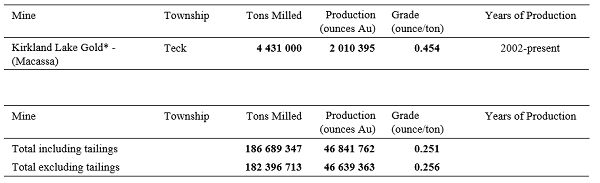
Sudbury District Report
An inconsistency in the use of “sample” number or numbers was noted in the Sudbury District report and is replaced by the word “station” in 3 specific sentences (bold text below indicates the corrections).
- On page 55, paragraph 4, line 4
“The apatite and allanite portion of the eastern margin of the pegmatite is locally radiogenic, as summarized in Table 32 (station numbers 19RME-3001).” - On page 55, paragraph 5, line 4
“This pegmatite is nonradiogenic (station number 19RME-3003, Table 32). It is hosted in a migmatitic mafic gneiss.” - On page 56, paragraph 1, line 3
“This pegmatite is also nonradiogenic (station numbers 19RME-3002, Table 32). It is hosted in a variably migmatitic, texturally varied, mafic gneiss.”
We regret any inconvenience these errors may have caused.
Amendment
Preliminary Map P.3838, Quaternary Geology of the Cochrane Area, Northeastern Ontario, Map P.3839, Quaternary Geology of the Abitibi Area, Northeastern Ontario, and Map P.3840, Quaternary Geology of the Iroquois Falls Area, Northeastern Ontario (all released June 11, 2019), have been updated to include information to indicate these maps are associated with Preliminary Map P.3836, Quaternary Geology of the Kapuskasing Area, Northeastern Ontario, and Map P.3837, Quaternary Geology of the Smooth Rock Falls Area, Northeastern Ontario (both released May 20, 2020). Maps P.3838, P.3839 and P.3840 have a new appearance, but the technical information provided in these maps has not changed. The updates are the following: 1) footnotes indicating that all 5 maps have a common legend were added to i) “Legend” and ii) “Symbols”; 2) Figure 1, the outline of the Cochrane extent of lidar digital terrain model data, was modified to include the lidar extents for all 5 map areas; and 3) the location map was modified to include the locations of all 5 maps.
If you have purchased a copy of P.3838, P.3839 and/or P.3840 and wish to receive replacement copies, please contact Publication Sales and the new version will be sent to you free of charge. Alternatively, the new versions of Preliminary Map P.3838, Preliminary Map P.3839 and Preliminary Map P.3840 are available for downloading free of charge on GeologyOntario.
Location Map (PDF)
Earth Resources and Geoscience Mapping Section
Surficial Mapping and Sampling
Preliminary Map P.3836
Quaternary Geology of the Kapuskasing Area, Northeastern Ontario; by A.S. Marich, scale 1:50 000, colour. $11.45
Preliminary Map P.3837
Quaternary Geology of the Smooth Rock Falls Area, Northeastern Ontario; by A.S. Marich, scale 1:50 000, colour. $11.45
Location Map (PDF)
Resident Geologist Program
Open File Report 6363
Report of Activities 2019, Resident Geologist Program, Red Lake Regional Resident Geologist Report: Red Lake and Kenora Districts; by W.P.E. Paterson, C. Ravnaas, S.O. Lewis, G.F. Paju, S.P. Fudge, C.M. Daniels and T.K. Pettigrew, 112p. $11.05
Open File Report 6364
Report of Activities 2019, Resident Geologist Program, Thunder Bay North Regional Resident Geologist Report: Thunder Bay North District; by R.M. Cundari, G.F. Paju, M. Dorado-Troughton, C.M. Daniels, S.P. Fudge, T.K. Pettigrew and G. Dorland, 79p. $10.20.
Open File Report 6365
Report of Activities 2019, Resident Geologist Program, Thunder Bay South Regional Resident Geologist Report: Thunder Bay South District; by M.A. Puumala, D.A. Campbell, G.F. Paju, C.M. Daniels, S.P. Fudge, T.K. Pettigrew and M. Dorado-Troughton, 105p. $10.90
Open File Report 6366
Report of Activities 2019, Resident Geologist Program, Timmins Regional Resident Geologist Report: Timmins and Sault Ste. Marie Districts; by E.H. van Hees, P. Bousquet, J. Suma-Momoh, C.M. Daniels, S.L.K. Hinz, C. Boucher, P. Sword, L. Wang, S.P. Fudge, A. Millette and C. Patterson, 160p. $10.40
Open File Report 6367
Report of Activities 2019, Resident Geologist Program, Kirkland Lake Regional Resident Geologist Report: Kirkland Lake and Sudbury Districts; by P.J. Chadwick, A.S. Péloquin, J. Suma-Momoh, C.M. Daniels, S.L.K. Hinz, C.A. Kennedy, L. Streit and R.M. Todd, 143p. $12.10.
Open File Report 6368
Report of Activities 2019, Resident Geologist Program, Southern Ontario Regional Resident Geologist Report: Southeastern and Southwestern Ontario Districts and Petroleum Operations; by P.S. LeBaron, N. Sabiri, D.A. Laidlaw, S.L.K. Hinz and L. Fortner, 72p. $9.50
Earth Resources and Geoscience Mapping Section
Aggregate Resources and Industrial Minerals
Aggregate Resources of Ontario—2019 (ARO—2019)
The Ontario Geological Survey (OGS) is releasing a GIS-based compilation of the aggregate resources of Ontario. This compilation is based on data compiled from aggregate resources inventory mapping conducted by the OGS from 1980 to 2019. It is intended that this compilation will be updated annually. This compilation includes data updated from the previously published information and may include newer geological data and/or mapping, where the latter are available.
It is important to note that this compilation is not intended to be used as a standalone product and the referenced original reports should always be consulted in conjunction with this compilation. Information contained within the referenced original reports (i.e., test results, resource properties and potential) is still highly relevant. However, it is possible that resource estimates provided in the referenced original reports may no longer be accurate, and may not reflect the data contained in this compilation. It must also be noted that, although the data represented in this compilation have been modified and updated since the release of the previously published information, the referenced original publications have not been revised to incorporate these changes.
The Aggregate Resources of Ontario—2019 (or ARO—2019) is available as a direct download from OGSEarth. The compressed (.zip) download file provides ARO—2019 data in geodatabase format using ESRI® ArcGIS® 9.3.1 with a completed project file (.mxd). Geospatial data are provided in North American Datum 1983 (NAD83) geographic co-ordinate system using decimal degrees. A user document and readme file that explains the GIS content is provided.
Surficial Geochemistry
Lake Geochemistry of Ontario (LakeGeochemON—2019)
The Ontario Geological Survey (OGS) is releasing a compilation of lake geochemical data for Ontario. The Lake Geochemistry of Ontario (LakeGeochemON—2019) compilation contains information for over 65 000 sample locations and 5.7 million geochemical analytical values and includes quality control (QC) data for blind duplicates and certified reference materials (CRMs). It is based on data compiled from 45 digital data releases (Miscellaneous Release—Data (MRDs)) published by the OGS between 1995 and 2018. It is intended that this compilation will be updated annually. This compilation augments a previous OGS digital compilation (MRD 153: Ontario Geochemistry and Indicator Mineral Database) published in 2005.
It is important to note that this compilation is not intended to be used as a standalone product and the referenced original reports should always be consulted in conjunction with this compilation in order to assist in understanding the significance of the geochemical data and relevance to mineral exploration.
The Lake Geochemistry of Ontario (LakeGeochemON—2019) compilation is available as a direct download from OGSEarth. The compressed (LakeGeochemON—2019.zip) download file provides 1) Lake Geochemistry data as a relational database (Microsoft® Access® 2016 (.accdb) file); 2) geospatial data (ESRI® shape file) providing the outline of each survey area; and 3) for user convenience, examples of several Ontario-wide data queries (exported as Microsoft® Excel® (.xlsx) files). Geospatial data are provided in North American Datum 1983 (NAD83) geographic co-ordinate system using decimal degrees.
Note: This is the first release in this configuration and it should be considered to be a “beta” version. We welcome comments and suggestions from users regarding changes to the query criteria, report form, etc. Any errors or omissions should be brought to the attention of the Ontario Geological Survey so that they can be corrected, and included in future updates of this compilation. Contact information is provided in the readme document.
Miscellaneous
The Ministry of Energy, Northern Development and Mines has prepared supplements for Miscellaneous Papers (MP) 177 and 178 to include publications released in 2019. Also, the Bedrock Geology Index to Maps and Surficial Geology Index to Maps are updated to include all maps released in 2019. Miscellaneous Paper 177 (Supplement 2011–2019), MP 178 (Supplement 2011–2019) and the maps are available as free downloads or can be purchased in hard-copy format from Publication Sales.
Miscellaneous Paper (MP) 177 (Supplement 2011–2019)
Index to Published Reports, Maps and Digital Data, 2011–2019
This report provides a listing of all publications released since the publication of MP 177 (Supplement 1993–2010), Index to Published Reports, Maps and Digital Data, 1993–2010. Publications are listed by series only.
Miscellaneous Paper (MP) 178 (Supplement 2011–2019)
Geographic Index to Published Reports, Maps and Digital Data, 2011–2019
This report provides a listing of all publications released since the publication of MP 178 (Supplement 1994–2010), Geographic Index to Published Reports, Maps and Digital Data, 1994–2010. Publications are indexed by geographic areas, which include National Topographic System (NTS) areas, geographic townships and Ministry of Natural Resources (MNR) “areas”. Publications are listed under the main geographic areas where they are located.
Index to Maps, Bedrock Geology, 1991–2019; produced by the Publication Services Unit, scale 1:1 000 000, colour. Available as a set of 4 maps. $12.00
Index to Maps, Surficial Geology, 1991–2019; produced by the Publication Services Unit, scale 1:1 000 000, colour. Available as a set of 4 maps. $12.00
Location Map (PDF)
Earth Resources and Geoscience Mapping Section
Groundwater Studies
Open File Report 6361
Regional-Scale Groundwater Geoscience in Southern Ontario: An Ontario Geological Survey, Geological Survey of Canada, and Conservation Ontario Geoscientists Open House; by E.H. Priebe, S. Holysh, D. Ford, H.A.J., Russell and J.E. Nadeau, compilers. 46p. $8.85
Location Map (PDF)