The GeologyOntario (includes OGSEarth) web pages will be updated with a new look in the coming weeks, starting at the end of September 2021.
The updated design improves the user experience by simplifying the layout, making the pages more mobile compatible, and aligning with other Ministry web pages.
Please contact Alphons Evers (alphons.evers@ontario.ca) if you encounter any issues after the change or have any questions.
During this update, this page will be removed. Please update your bookmark to the following: Bedrock Topography and Overburden Thickness.
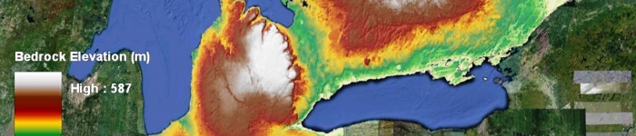
Bedrock Topography and Overburden Thickness contain a bedrock elevation map and information on the thickness of material deposits above the bedrock surface.
Data includes: an interpolated bedrock surface created from a variety of existing point data, a bedrock shaded relief grid and an interpretation of overburden thickness.
Download the Bedrock Topography and Overburden Thickness data in GIS format.