The GeologyOntario (includes OGSEarth) web pages will be updated with a new look in the coming weeks, starting at the end of September 2021.
The updated design improves the user experience by simplifying the layout, making the pages more mobile compatible, and aligning with other Ministry web pages.
Please contact Alphons Evers (alphons.evers@ontario.ca) if you encounter any issues after the change or have any questions.
During this update, this page will be removed. Please update your bookmark to the following: OGSFocus.
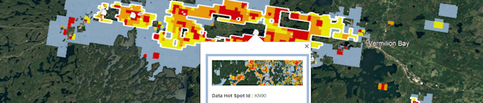
OGSFocus is a series of map layers that quantify data from the Ontario Assessment File Database (OAFD), Ontario Drill Hole Database (ODHD) and Mineral Deposit Inventory (MDI) database.
Data includes: A Data Rating Grid for Open Areas that provides a visual representation of the quantity of exploration data available and a Data Hot Spots layer that highlights significant contiguous areas with robust data that are available for acquisition.
Download the OGSFocus datasets in GIS format (Updated bi-weekly. Last updated October 1, 2021)
An alternate version of the data rating grid is available that does not exclude Mining Lands Administration System (MLAS) provincial grid cells that have active mining land tenure on the date of release.